The Sea Chart: The Illustrated History of Nautical Maps and Navigational Charts [Book]
Product Specification
-
Authors: John BlakePages: 160Format: paperbackPublication Date: July 1, 2009Key Terms: British Crown Copyright, portolan chart, rhumb lines, Admiralty, Pepys Library, Spice Islands, Australia, Royal Geographical Society, compass rose, Portuguese, Alexander Dalrymple, Cape Horn, Francis Beaufort, North America, James Cook, George Vancouver, Royal Navy, Samuel Wallis, Weddell Sea, Nootka Sound
-
Universal Product Identifiers
ISBN: 1844860639GTIN: 09781844860630
Related Products
-
4G Broadband Radar with 10M Cable 000-10419-001 c42913
-
SM-24-R Sailboat and Trawler Mast Platform
-
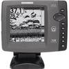
700 Series 718 - Fishfinder - included transducer : XNT-9-20-T - dual-beam
-
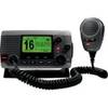
010-00754-00 - VHF 100, Basic, Grey
-
AP2401 Autopilot AP24,AC12,RC42,RF300 No Drive
-
Andr� Previn - Play Showboat [Digital Version]
-
Ethernet Category 6 Enhanced RJ45 Network Patch Cable - 7' Black.
-
30ft 24AWG Cat5e 350MHz UTP Bare Copper Ethernet Network Cable - Purple
-
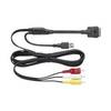
CCA750 - iPhone / iPod audio / video / data cable - Male Apple Dock connector to M 4 pin USB Type A, RCA
-
50ft Premier Series XLR Male to XLR Female 16AWG Cable (Gold Plated) [Microphone & Interconnect]
-
PL-258-L-G Bulkhead Barrell Connector for PL-259
-
B117-DT-HB 600W Thru Hull Transducer Humminbird #9 Connector