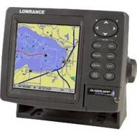
GlobalMap 5300C iGPS - Marine GPS receiver - 5" color - 480 x 480
Model: 5300C Brand: Lowrance
Product Specification
-
General
Product Type: GPS receiverRecommended Use: MarinePreloaded Maps: USA, HawaiiReceiver: 12 channelCard Reader: SD Memory CardInterface: NMEA 0183, NMEA 2000Functions & Services: MOB (Man Overboard)Compatible Software: Lowrance NauticPath USA Marine Electronic Charts, Lowrance Fishing Hot Spots Elite, Lowrance FreedomMaps USA Topo, Lowrance LakeMaster Pro Maps, Lowrance MapCreate USA TopoSBAS: WAASAntenna: Built-inUpdate Rate: 1/secondFeatures: Backlit keypadFirst Seen On Google Shopping: August 2007 -
Display
Type: TFT - colorDiagonal Size: 5"Resolution: 480 x 480Display Illumination: Yes -
Navigation
Waypoints: 1000Tracks: 10Tracklog Points: 9999Routes: 100Waypoints per route: 100 -
Connections
Interfaces: Serial - RS-232 -
Miscellaneous
Protection: WaterproofIncluded Accessories: SD Card -
Dimensions & Weight
Width: 6.9 inDepth: 3.4 inHeight: 5.4 in -
Manufacturer Warranty
Service & Support: 1 year warranty -
Universal Product Identifiers
Part Numbers: 116-29, 5300C iGPSGTIN: 00042194529578
Related Products
-
AP2403VRF Autopilot AP24,AC12,RC42,RPU80
-
46-27 SB-10BL Switch Box, 2 Sonar-1 Transducer
-
010-C0761-10 Bluechart G2 HEU002RDover to Amsterdam & England
-
ACR Replacement Antenna for Satellite 406 #9322
-
Fastfind Max - PLB, Fastfind Max 406 PLB 48hr Battery Revere Supply
-
2742.91 FBRS 2742 Battery Replacement Service
-
Bulk cable - CAT 6 - Unshielded twisted pair (UTP) 1000 ft - Orange
-
4033 30ft 22AWG CL2 Standard HDMI Cable - Black
-
Th-1202-B Thru Hull 1-1/8" White 1-1/4" Hull
-
18-8804-1 Premium Marine Spark Plug Wire Leads
-
3ft 24AWG Cat6 550mhz UTP Ethernet Bare Copper Network Cable - Orange
-
Approach S1W - Golf GPS receiver - 1" monochrome - 64 x 32