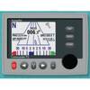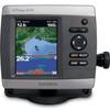
GPSMAP 420 - Marine GPS receiver - 4" color - 240 x 320
Model: 420 Brand: Garmin
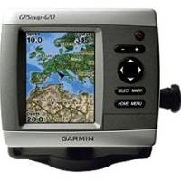
The GPSMAP 420 is a sleek, space-saving chartplotter that features an ultra-bright 4" QVGA display, built-in satellite-enhanced worldwide basemap, and simplified user operation. The 420 also has an SD card slot so you can add additional features with the optional BlueChart g2 Vision card. The 420's basemap contains worldwide satellite images in place of more traditional maps, and its SD card slot makes it easy to add additional maps without connecting to a computer. With fewer keys and a simple, intuitive interface, the 420 makes navigating your way through the water easy. « less
Product Specification
-
General
Product Type: GPS receiverRecommended Use: MarineReceiver: 12 channelCard Reader: SD Memory CardInterface: NMEA 0183Functions & Services: MOB (Man Overboard)Compatible Software: BlueChart g2 VisionGrids: UTM, Lat/Lon, UPS, Loran TDs, MaidenheadSBAS: WAASDGPS: DGPS readyAntenna: Built-inAccuracy: Position - 49 ft Velocity - 0.16 ft/sec Position - 10 ft ( with WAAS )Update Rate: 1/secondFeatures: Optional external GPS antenna connection, alarm, 2D / 3D map perspectiveFirst Seen On Google Shopping: March 2007 -
Display
Type: LCD - colorDiagonal Size: 4"Resolution: 240 x 320 -
Acquisition Times
Warm: 15 secCold: 45 sec -
Navigation
Waypoints: 1500Tracks: 20Tracklog Points: 10000Routes: 20Trip Computer: TracBack, sunrise/sunset times, sun/moon positions -
Connections
Interfaces: Antenna -
Miscellaneous
Body Material: ABS plasticDesign Features: Rugged caseProtection: WaterproofWaterproof Standard: IPX7Included Accessories: Protective cover, mounting bracket, power/data cable -
Dimensions & Weight
Width: 5.7 inDepth: 2.7 inHeight: 5 inWeight: 1.3 lbs -
Environmental Parameters
Min Operating Temperature: 5 °FMax Operating Temperature: 131 °F -
Universal Product Identifiers
Part Numbers: 010-00515-20, 420GTIN: 00689076730587, 00753759065720
Related Products
-
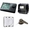
Commander Color Display with SSRC1 Rate Gyro Compass & Linear Feedback 10110035
-
E70014 C127 Multifunction Display w/Sonar - No Preloaded Cha
-
Radar Pole Mount 6' Kit for Garmin/Furuno Domes 36177
-
T52074 4KW 72 Open Array W 15m Cable
-
AP2804 Autopilot System AP28,AC42,RC42,RF300,RPU160
-
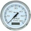
Marine Instruments 33832 0-6000 rpm Tachometer with Hourmeter
-
Instrument Package for Harley-Davidson Fairing models 2004-2012 - Blue LED MCL-3006-OT
-
Ethernet Category 6 Enhanced RJ45 Network Patch Cable - 7' Black.
-
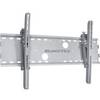
Adjustable Tilting Wall Mount Bracket for LCD LED Plasma (Max 165Lbs, 52~71inch) - Extra Wide - Silver
-
Orange Six Inch Category 5 Enhanced Cat 5e Ethernet Network Cable .5
-
3ft 24AWG Cat5e 350MHz UTP Bare Copper Ethernet Network Cable - Red
-
GPSMAP421S Color Combo SOUNDER/GPS w/TM Transducer