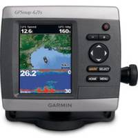
GPSMAP421S Color Combo SOUNDER/GPS w/TM Transducer
Model: GPSMAP421S Brand: Garmin
The GPSMAP 421s is a compact chartplotter that features an ultra-bright 4? QVGA color display along with an improved high-speed digital design for increased map drawing and panning speeds. Its ready to go with a built-in, satellite-enhanced worldwide basemap and an easy-to-use interface designed to help you navigate the open waters with ease. The GPSMAP 421s also accepts BlueChart g2 Vision cards for added features and functionality such as high-resolution satellite imagery, 3D views and Auto Guidance technology and a powerful dual-frequency fish finder that clearly illustrates depth contours, fish targets and structures whether youre fishing in freshwater or off the coast. View Satellite-enhanced Worldwide Basemap The GPSMAP 421s basemap contains worldwide satellite images in place of traditional maps. The GPSMAP 421s also comes standard with a high-sensitivity GPS receiver for superior satellite tracking and quicker acquisition times. In addition, the GPSMAP 421s can receive U.S. graphical weather data via optional GXM 51 satellite receiver/antenna. And with an SD card slot, its easy to add additional maps without connecting to a computer. Add Extras with BlueChart g2 Vision With the optional BlueChart g2 Vision SD card, you can add a whole new dimension of exceptional features to your chartplotter. 3D Mariners and Fish Eye view provides you with a 3-dimensional perspective of map information, both above and below the waterline High-resolution satellite images and aerial photographs help you orient yourself in unfamiliar areas Auto Guidance technology searches through all relevant charts to create a route you can actually follow one that avoids obstacles, shallow water, buoys and other obstructions Physical & Performance: Unit dimensions, WxHxD: 5.7" x 5.0" x 2.7" (14.5 x 12.7 x 6.9 cm) Display size, WxH: 2.4" x 3.2", 4.0" diagonal (6.1 x 8.1 cm, 10.2 cm diagonal) Display resolution, WxH: 240 x 320 pixels Display type: QVGA display Weight: 1.3 lb (590 g) Battery: none Battery life: none Waterproof: yes (IPX7) High-sensitivity receiver: yes Antenna: internal NMEA input/output: NMEA 0183 compatible and NMEA 2000 certified Maps & Memory: Basemap: yes Preloaded maps: no Ability to add maps: yes Built-in memory: none (cannot load maps to internal memory) Accepts data cards: SD? card slot Waypoints/favorites/locations: 3,000 Routes: 100 Track log: 10,000 points; 50 saved tracks Features: Garmin radar compatible: no Garmin sonar compatible: yes CANet compatible: no Garmin Marine Network? "Turn right in 500 ft."): no Speaks street names (e.g. « less
Product Specification
-
Universal Product Identifiers
Part Number: GAR0100076401
Related Products
-
Elite 5 DSI - Fishfinder - included transducer : Skimmer DSI
-
PAPR08; Region 8 Paper Chart Kit
-
BlueChart g2 Vision - South Maine - Maps
-
BlueChart g2 Vision - Vancouver Island - Dixon Entrance - Maps
-
4119 Channel Isls/Venture - Santa
-
LTD ZDIGAIS100 USB AIS Receiver
-
Molex(5.25 Female) / Molex(5.25 Female), Int. DC Power Cable
-
25ft 24AWG Cat6 500mhz Crossover Ethernet Bare Copper Network Cable - Gray
-
GP1920C-NT VX2 Chartplotter C-Map NT
-
Marine Speaker Cable - XM-WHTSC16-25
-
Pandora Featured Network audio player
-
Marine Products Plug Wire Set, Mercruiser V-8, 9-28000