4119 Channel Isls/Venture - Santa
Model: 4119 Brand: Fish-n-Map
FISH-N-MAP UNDERWATER TOPOGRAPHY MAPSMade of waterproof, tear resistant plastic. Features include: underwater depth contours, fish locations, latitude and longitude for GPS, multiple freshwater lakes on one map, boat ramps, recreational facilities and much more.
Product Specification
-
Universal Product Identifiers
Part Numbers: 4119, 516252GTIN: 00761428041197
Related Products
-
Max AS-M201 W53 Gulf of Thailand Hainan Dao-MAX
-
E70022 E97 Multifunction Display w/Sonar - No Charts
-
X67-C Sonar [DVD]
-
GMR24 HD Radar 24 Inch 4KW 48NM Range High Definition Dome with 15 Meter Cable 010-00572-03
-
Radar Mount, Edson Basic Fixed Flybridge Tower System for 8 to 16 Mile Radars
-
Nickel Compass Chart Weight & Pen Set
-
2776.91 FBRS 2776 Battery Replacement Service
-
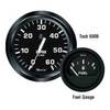
Gauges 12821 Euro Voltmeter 10-16v for Al
-
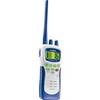
Atlantis 250- Handheld VHF 2-Way Marine Radio
-
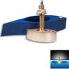
B260-BB 1kW Thru-Hull Transducer Standard 8-Pin Connector
-
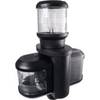
Ltb Top - Universal Box Top for All Round, Masthead & Stern Lights LTB-BOX
-
n�vi 2555LT - Automotive GPS receiver - 5" color - 480 x 272 - widescreen