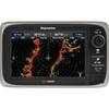
HDS-10 - Marine Chartplotter - 10.4" color - 800 x 600
Model: HDS-10 Brand: Lowrance
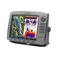
The HDS-10 fishfinder / GPS chartplotter from Lowrance features a stunning high-definition 10.4” / 26.4 cm Super VGA color viewing. The SolarMAX PLUS display renders brilliant detail in sunlight with the best wide-angle viewing, while advanced pure-white LED screen / keypad backlighting fully adjusts to zero-dim for night fishing. The unique FlyWheel dial and command soft keys give you easier and quicker control of broadband sounder fishfinding and satellite navigation precision via the built-in 16-channel antenna. « less
Product Specification
-
General
Product Type: ChartplotterRecommended Use: MarinePreloaded Maps: WorldwideReceiver: 16 channelCard Reader: SD Memory Card, MultiMediaCardInterface: NMEA 0183, NMEA 2000Functions & Services: MOB (Man Overboard)Compatible Software: Navionics Platinum, Lowrance Fishing Hot Spots PRO, Lowrance LakeMaster Pro MapsSBAS: WAAS, EGNOS, MSASAntenna: Built-inFeatures: Depth sounderFirst Seen On Google Shopping: March 2011 -
Display
Type: TFT - colorDiagonal Size: 10.4"Resolution: 800 x 600Display Illumination: YesFeatures: Split screen zoom, HyperScroll, FasTrack, Grayline, FishTrack, Advanced Signal Processing (ASP), Fish Symbol ID, COLORLINE, FlashGraf -
Transducer
Transducer Presence: Optional transducerTransducer Type: Skimmer - dual-beamMaximum Depth: 5000 ftPower Output (Peak to Peak): 250 WPower Output (RMS): 31 W -
Navigation
Waypoints: 5000Routes: 200 -
Connections
Interfaces: Ethernet -
Miscellaneous
Protection: Waterproof -
Dimensions & Weight
Width: 12.3 inDepth: 3.6 inHeight: 8.9 in -
Manufacturer Warranty
Service & Support: 2 years warranty -
Universal Product Identifiers
Part Numbers: 000-0140-03, HDS-10, LOW14013GTIN: 00042194532929, 00042194533292, 00874205199582
Related Products
-
T-940-3 4KW 3.5' Open Array Radar
-
JMA-5110 Black Box Radar 72NM, 10KW with 6 Foot Open Array (without LCD Display)
-
PAPR08; Region 8 Paper Chart Kit
-
AP2401 Autopilot System AP24 AC12 RC42 RF300 No Drive
-
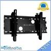
Adjustable Tilting Wall Mount Bracket for LCD LED Plasma (Max 165Lbs, 23~37inch) - Black (No Logo)
-
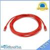
10ft 24AWG Cat5e 350MHz UTP Bare Copper Ethernet Network Cable - Red
-
WS-CC30 NMEA Combination Cable 30m
-
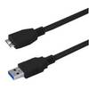
USB 3.0 Micro Cable | 10ft | Type A | Micro Type B | Black
-
25ft DVI-I to 3 RCA Component Video Cable (DVI-I - 3-rca)
-
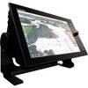
NavNet TZtouch TZT14 14.1" Multifunction Display
-
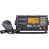
M604A VHF Radio - Black IC-M604A 41
-
E62355 - e7D, 7 GPS/MFD/Sonar w/o Charts