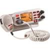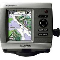
GPSMAP 440 - Marine GPS receiver - 4" color - 240 x 320
Model: 440 Brand: Garmin
Offshore fishermen and boaters will gravitate toward this sleek, space-saving chartplotter. The GPSMAP 440 features preloaded detailed maps for the U.S. coast as well as an ultra-bright 4" QVGA display; built-in, satellite-enhanced worldwide basemap and simplified user operation. The 440 has preloaded detailed maps that cover all U.S. coastal areas, including Alaska and Hawaii. For areas outside the U.S., the 440 has a worldwide basemap with satellite images in place of more traditional maps, and its SD card slot makes it easy to add additional maps without connecting to a computer. With fewer keys and a simple, intuitive interface, the 440 makes navigating your way through the water easy. Where applicable, the sounder version, GPSMAP 440s, comes with a powerful dual frequency transducer that clearly paints depth contours, fish targets and structure. It's also CANet compatible, so you can share sounder data with another chartplotter on your boat. The weather-enabled versions, GPSMAP 440x and 440sx, display XM satellite weather data, including NEXRAD radar, with the GXM 31 antenna. « less
Product Specification
-
General
Product Type: GPS receiverRecommended Use: MarinePreloaded Maps: USAReceiver: 12 channelCard Reader: SD Memory CardInterface: NMEA 0183Functions & Services: MOB (Man Overboard)Compatible Software: BlueChart g2 VisionGrids: UTM, Lat/Lon, UPS, Loran TDs, MaidenheadSBAS: WAASDGPS: DGPS readyAntenna: Built-inAccuracy: Position - 49 ft Velocity - 0.16 ft/sec Position - 10 ft ( with WAAS )Update Rate: 1/secondFeatures: Depth sounder, optional external GPS antenna connection, alarm, 2D / 3D map perspectiveFirst Seen On Google Shopping: May 2007 -
Display
Type: LCD - colorDiagonal Size: 4"Resolution: 240 x 320 -
Acquisition Times
Warm: 15 secCold: 45 sec -
Navigation
Waypoints: 1500Tracks: 20Tracklog Points: 10000Routes: 20Trip Computer: Sunrise/sunset times, sun/moon positions -
Connections
Interfaces: Antenna -
Miscellaneous
Body Material: ABS plasticDesign Features: Rugged caseProtection: WaterproofWaterproof Standard: IPX7Included Accessories: Protective cover, mounting bracket, power/data cable -
Dimensions & Weight
Width: 5.7 inDepth: 2.7 inHeight: 5 inWeight: 1.3 lbs -
Environmental Parameters
Min Operating Temperature: 5 °FMax Operating Temperature: 131 °F -
Universal Product Identifiers
Part Numbers: 010-00515-40, 440GTIN: 00753759065751
Related Products
-
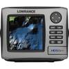
HDS-5m Nautic Insight Chartplotter - Coastal Data 34262
-
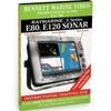
DVD - Raymarine E Series E80 E120 Sonar, N7801DVD
-
Package(e97 with aus, NZ, S. America, Asia Chart, 4KW 24 Inch Digital Radome & Radar Cable)
-
Nootka Sound Chart
-
BlueChart g2 Vision - Wrangell to Dixon Entrance - Maps
-
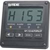
SP110RF-3 System with Rudder Feedback and Type S Mechanical Das
-
Mr F75-D Marine Class-D Digital Selective Calling Technolog
-
Marinenav Explorer Marine Navigation PC Computer EXP-013-AMD
-
010-C0761-10 Bluechart G2 HEU002RDover to Amsterdam & England
-
50ft 28AWG DVI-D USB (A Type) to M1-D (pd) Cable - Black
-
000-0136-02 - 50/200kHz /T, PL Lo-Pro Xdcr, Blue CON
-
ME-AGS-N - Automatic Gen Start Module, Network