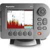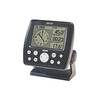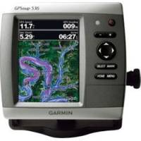
GPSMAP 536s - Marine Chartplotter - 5" color - 480 x 640
Model: 536s Brand: Garmin
The GPSMAP 536s is a compact chartplotter that features a high-resolution, super-bright 5" VGA color display along with an improved high-speed digital design for increased map drawing and panning speeds. It's ready to go with a built-in, satellite-enhanced basemap and an easy-to-use interface designed to help you navigate the open waters with ease. The GPSMAP 536s also accepts BlueChart g2 Vision cards for added features and functionality such as high-resolution satellite imagery, 3-D views and Auto Guidance technology. The GPSMAP 536s has a worldwide basemap with satellite images in place of more traditional maps. The GPSMAP 536s also comes standard with a high-sensitivity GPS receiver for superior satellite tracking and quicker acquisition times. With an SD card slot, it's easy to add additional maps without connecting to a computer. The GPSMAP 536s is also NMEA 2000-certified for easy connectivity with sensors, instruments and future marine offerings. « less
Product Specification
-
General
Product Type: ChartplotterRecommended Use: MarineCard Reader: SD Memory CardInterface: NMEA 0183, NMEA 2000Functions & Services: Tide TabIncluded Software: MapSource BlueChart Inland Lakes: United StatesCompatible Software: BlueChart g2 VisionFeatures: Optional external GPS antenna connection, XM weather supportFirst Seen On Google Shopping: February 2011 -
Display
Type: LCD - colorDiagonal Size: 5"Resolution: 480 x 640 -
Transducer
Transducer Presence: Included transducerTransducer Type: Dual-beam -
Navigation
Waypoints: 3000Tracks: 50Tracklog Points: 20000Routes: 100Trip Computer: Sun/moon positions -
Miscellaneous
Protection: WaterproofWaterproof Standard: IPX7Included Accessories: Protective cover, mounting bracket, power/data cable -
Dimensions & Weight
Width: 5.9 inDepth: 2.9 inHeight: 6.4 inWeight: 1.8 lbs -
Universal Product Identifiers
Part Numbers: 010-00773-01, 536sGTIN: 00753759096144
Related Products
-
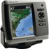
E62186US E62186-US E62186 US A50D 5" Fishfinder - Chartplo
-
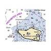
NOAA Rosario Strait-Southern Part Chart
-
The Nautical Chart [Book]
-
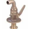
Bronze Seacock, 1 Inch Adapter, 90 Degree 0834006PLB
-
14ft 24AWG Cat6 550mhz UTP Ethernet Bare Copper Network Cable - Gray
-
GPS 152 - Marine GPS receiver - 4" monochrome - 100 x 160
-
10ft USB 2.0 A Male to Micro 5pin Male 28/24AWG Cable w/ Ferrite Core (Gold Plated)
-
25ft Premium Optical Toslink Cable w/ Metal Fancy Connector
-
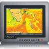
G120 Marine Display 12 Inch E62247 c31585
-
100A Marine Electrical Shore Power Blank Adapter
-
SeatalkHS Network Cable
-
010-00772-01 GPSMAP 526S Marine GPS Receiver