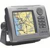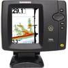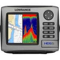
HDS-5 Nautic Insight Remanufactured No Ducer #055-0140-31
Model: HDS-5 Brand: Lowrance
HDS-5 Multifunction Fishfinder/Chartplotter - *Remanufactured* w/o transducer NEW SOLARMAX+ DISPLAY Exclusive, high brightness 480x480-pixel 5-inch display for the truest representation of sonar graph and navigational detail Sunlight viewable screen/keypad backlighting with brighter, clearer, wide-angle viewing HIGH-DEFINITION FISHFINDING Unequalled Lowrance sounder performance now enhanced with built-in Broadband Sounder technology inside. Superior clarity and up to an astounding 120-degree view of water column to find more fish. Phenomenal separation of fish targets from structure, baitfish, thermoclines, clutter and bottom. Improved underwater fish-holding structure identification; channels, rock piles, stump beds, submerged standing timber, drop-offs and more. Exceptional fish-finding performance in any water/weather situation, at all depths and at any speed. Peerless bottom tracking performance now with up to 8X zoom range. COLORLINE? enhances target separation and bottom composition definition. Maintains full suite of advanced, Lowrance professional grade fishfinder features and functions. HIGH-DEFINITION MAPPING Built-in high sensitivity GPS antenna with superior time-to-location lock and precision position -- NMEA 2000? networkable Optional LGC-4000 external GPS antenna module with high speed 5 Hz update rate available for custom applications -- NMEA 2000? Exclusive Fishing Hot Spots? fishing points of interest content, including marked fishing areas, boat launches and fish habitat areas. Lightning-fast redraws and display refresh. Nautic Insight? coverage for Great Lakes and U.S. coastal waters Supports all Navionics? content including Platinum Plus, Platinum and Platinum Hot Maps on plug-and-play memory cards Also supports all legacy Lowrance charts Lake - Maps surveyed lakes with high-detail depth contours. Fishing Hot Spots? PRO with fishing points of interest. - Path? offshore/coastal maps, Freedom - Maps? land and lake topographic maps and Map - Create USA Series 7. SUPERIOR INTERFACE Attractive new case design that is easier to install Waterproof SD/MMC memory card slot to plug-and-play high-detail cartography options, save-load user GPS data Newest high-capacity high-speed flash memory for user functions and cartography storage reduces case size for a more compact performance package Enhanced menu structure offers quick and easy access to most-used features Improved keyboard design for more intuitive and ergonomic control in all weather conditions ADVANCED NETWORKING & EXPANDABILITY Simplified high-speed Ethernet-based networking shares useful sonar, navigation and radar data Exclusive new SIRIUS Satellite Weather and Audio smart antenna module, with ethernet output to displays and high quality audio output to any onboard stereo; available with unique SIRIUS subscription packages Coastal content package including full suite of weather and sea conditions 120 channel crystal clear audio functionality added for a small additional monthly fee Compatible with Lowrance High Definition Digital Radar radome options with radar/chart overlay feature (with optional heading sensor) NMEA 2000? network connectivity for easy multi-station data sharing to monitor and display boat operation systems via onboard and engine sensors Maximize fuel economy with Fuel Flow sensors or digital Engine Interface sensors. Precision temperature sensor option for surface water, livewell, baitwell, cabin and/or engine room readings. Compatible with all other NMEA 2000?-certified sensors from Lowrance -- including speed, fluid level and pressure sensors - or other manufacturers. Track-Your-Buddy and Get-Buddy features in addition to DSC when interfaced with Lowrance-compatible VHF marine radios NMEA 0183 compatible « less
Product Specification
-
Universal Product Identifiers
Part Number: 055-0140-31
Related Products
-
HDS-5 Baja GPS 34274
-
X515c DF 5" Dual Frequency Sonar 123-34
-
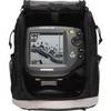
500 Series 565 Portable - Fishfinder - portable - included transducer : XNT-9-20-T - dual-beam
-
BlueChart g2 Vision - Wrangell to Dixon Entrance - Maps
-
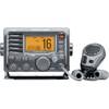
M504 Gray VHF Radio with Hailer
-
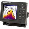
500 Series 596c - Fishfinder - included transducer : XNT-9-20-T - dual-beam
-
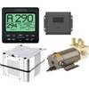
AP2403VRF Autopilot AP24 AC12 RC42 RPU80
-
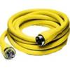
HBL61CM52 - Marine Cord Set, Shore Power, 50ft, 50A
-
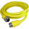
30 Amp 50' Cord Set - Yellow - 125V
-
30 Amp 75' Cord Set - Yellow - 125V
-
6ft Premier Series XLR Male to RCA Male 16AWG Cable (Gold
-
E22158 SeaTalk 1 to SeaTalk NG Converter Kit