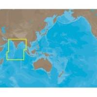
IN-M002 SD Card Format Indian Ocean
Model: IN-M002 Brand: C-Map
Coverage of Indian Ocean. It covers coastal areas along Mauritiuis, Seychelles, United Kingdom, Maldives, India, Gulf of Kachchh, Colombo, Bangladesh, Rangoon in Burma, Pluket in Thailand and Banda Ache in Indonesia.
Product Specification
-
Universal Product Identifiers
Part Numbers: IN-M002, IN-M002SDCARD
Related Products
-
Ocean Chart Lamp, Small
-
The Nautical Chart Movie Photo Print (11 x 17)
-
Lake Champlain Fishing North - Waterproof Charts
-
dq2954 25-Watt VHF Marine Class D DSC Mount Radio
-
3550G7 LED Navigation Light Green
-
CANNON 720076-1 as DPS Y Serial Port Splitter Cable
-
European Style Navigation Lights, Red Side Light, Black Perko
-
50ft 24AWG Cat6 550mhz UTP Ethernet Bare Copper Network Cable - Gray
-
Bulk cable - CAT 5e - Unshielded twisted pair (UTP) 1000 ft - Purple
-
6ft 32AWG Mini DisplayPort Cable - White
-
AFI Chart Light & Cigarette Lighter, Economy, 12Pack
-
GlobalMap 5200C - Marine GPS receiver - 5" color - 480 x 480