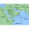
Inc MSD/PREM-N6 Map, HotMaps Premium North
Model: PREM-N6 Brand: Navionics
HotMaps Premium 2D Lake Maps - with 1000 of Navionics exclusive high-definition lake maps to 1' contours plus, over 15,000 additional lakes with underwater structure, improved accuracy, major roads, county lines and more. FREE Fish'N Chip high-definition fishing detail for US Great Lakes waters now included in HotMaps Premium Canada, North and East regions. North: Covers IA, MI, MN, WI, ND, SD « less
Product Specification
-
Universal Product Identifiers
Part Numbers: 10205396, 11094356, 37625, MSD-PREM-N6, PREM-N6, SD/PREM-N6GTIN: '82124541594, 00821245415943
Related Products
-
MapSource BlueChart - Red Sea - Maps
-
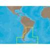
SA-C003 Furuno FP Format - Rio de Janeiro - Cape Horn
-
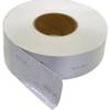
Scotchlite 50.8mm X; 50m, Grade 3150A REFELEC
-
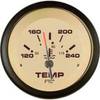
59706P Sahara Instrument- Water Temp Gauge 120-240
-
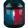
Navigation Light for Bulk Head Mounting Bi Color
-
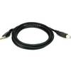
6ft USB 2.0 A Male to B Male 28/24AWG Cable - (Gold Plated)
-
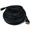
4161 20ft 24AWG CL2 Flat Standard HDMI Cable - Black
-
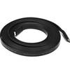
50ft 22AWG CL2 Standard HDMI to DVI Adapter Cable - Black
-
10ft RG6 (18AWG) 75OHM, Quad Shield, CL2 Coaxial Cable with F Type Connector - White
-
2018 Dual PowerPost Cable Connectors
-
2201 Black Terminal Feed Through Connector
-
GlobalMap 8300C HD - Marine GPS receiver - 8.4" color - 600 x 800