4125 Map -San Diego/Ensenada
Model: 4125 Brand: Fish-n-Map
FISH-N-MAP UNDERWATER TOPOGRAPHY MAPSMade of waterproof, tear resistant plastic. Features include: underwater depth contours, fish locations, latitude and longitude for GPS, multiple freshwater lakes on one map, boat ramps, recreational facilities and much more.
Product Specification
-
Universal Product Identifiers
Part Numbers: 4125, 7101066GTIN: 00761428041258
Related Products
-
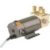
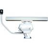
21118245 RPU300 Hydraulic Pump Drive
-
Package(c127 with USA Coastal Chart, 4KW 24 Inch Digital Radome & Radar Cable)
-
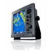
JMA-3340HS Radar 10KW 72 nm, 4 ft Open Array with 27-48 rpm Radar Antenna
-
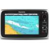
C97 9" Display w/ Sounder and US Coastal Charts
-
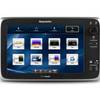
T70056 E125 Multifunction Display w/US Inland Charts
-
ICE 35 - Fishfinder - portable - included transducer : XI 9 19 - dual-beam
-
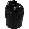
PHF1 Female Phone Connector
-
P66-BL with Lowrance Blue Connector 50/200 D/S/T
-
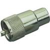
329900-1 UHF Connector Male F/8U Cable
-
6 Inch Power Mount for Northstar & Simrad Open Array with Light Option (Aft Leaning) PMA-6NO-8L ( PMA-57-M1 + ADA-R1)
-
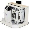
FCF-5000 Feel Cool Fast Marine Air Conditioner by Webasto
-
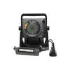
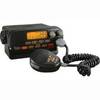
Mr F55 Fixed Mount VHF Radio, Fixed Mount VHF 1-25 Watt Black Cobra