Marine Navigation: Piloting [Book]
Product Specification
-
Authors: Richard R. HobbsPages: 292Format: hardbackPublication Date: 1974Key Terms: Notice to Mariners, gyrocompass, nautical charts, Tide Tables, daybeacons, daymarks, Mercator chart, buoy, radar, rhumb line, U.S. Navy, set and drift, gnomonic projection, Coast Pilot, dead reckoning, Light List, gyro, anchorage, Brooklyn Bridge, magnetic compass
-
Universal Product Identifiers
ISBN: 0870212044GTIN: 09780870212048
Related Products
-
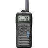
m92-01 Portable Class D DSC VHF Marine Radio with GPS icmm9201
-
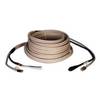
000-167-638 30m Cable
-
PAPR07; Region 7 Paper Chart Kit
-
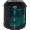
41220-1 S41 Starboard Navigation Light 24V, Black
-
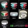
Lopo Light Masthead (3nm)
-
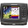
000-10531-001 HDS-7 Gen2 Insight USA w/o Transducer
-
Manhattan iLynk 2-in-1 Cable - iPad / iPhone / iPod / cellular phone charging / data cable kit
-
DA75S - Antenna Adapter Cable, Sierra Wireless
-
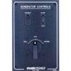
Paneltronics 9982301B Standard 120/220V AC Ship to Shore Selector
-
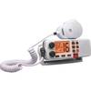
Regatta 1 25W VHF Radio - White CW32225
-
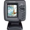
386ci GPS Fishfinder 409030-1 c46181
-
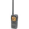
Low2217 LHR-80 VHF GPS Handheld Marine Radio