Marine Navigation Workbook: Piloting and Celestial and Electronic Navigation [Book]
The standard navigation textbook at the U.S. Naval Academy and NROTC college programs for twenty-five years, this highly regarded reference has trained more than two generations of students on the practice of marine navigation in the U.S. Navy. All aspects of the duties, practices, and responsibilities of the Navy surface navigator at sea are covered. Long praised for its clarity and thoroughness, the text has now been revised and updated to reflect the latest changes in marine navigation technology and government publications.In this fourth edition all sight forms reflect those now in use in the U.S. fleet. Also included is new summary information on currently available computer navigation applications programs and new information on world geodesy and global positioning systems. Appendixes present the most important pages of Chart No. 1 and selected tables from the American Practical Navigator (Bowditch).Also available is the Marine Navigation Workbook, a chapter-by-chapter compendium of supplemental,queries and problems designed to assist the student to master the material presented in the textbook -- complete with a handy three-ring binder. An appendix provides complete answers and solutions to all odd-numbered problems along with plotting sheets and forms. A new Instructor's Answer Key is available to bona fide instructors. « less
Product Specification
-
Authors: Cdr Richard R HobbsPages: 400Format: paperbackPublication Date: November 1, 1997Key Terms: Nautical Almanac, set and drift, sextant, daylight savings, Loran-C, Polaris, Fomalhaut, gyrocompass, nautical chart, Mercator chart, celestial navigation, celestial coordinate system, applications software, Celestial horizon, Achernar, LEARNING OBJECTIVES, Arcturus, Acrux, weather fronts, Tide Tables
-
Universal Product Identifiers
ISBN: 1557503850GTIN: 09781557503855
Related Products
-
AIS Radar with 5 in Display Requires VHF Ant
-
T62289 - C90W/RD418D/10M Cable System Pack
-
010-C0763-10 Bluechart G2 HEU004RIrish Sea Data Card
-
010-C1020-10 Bluechart G2 HPC024RAustralia & New Zealand Data
-
Flotation Cushion Red
-
1" Seacock Body
-
MD3-6H Life Raft 6 Person Hard Canister
-
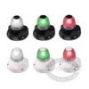
Marine Naviled 360 All-Round Navigation Light
-
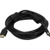
2529 15ft 28AWG Standard HDMI Cable w/Ferrite cores - Black
-
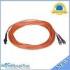
2640 Fiber Optic Patch cable,mtrj (m)/st,10m
-
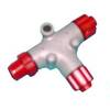
N2K-T-Rd T Connector Red NMEA Network c30933
-
LHR-80 VHF/GPS Handheld Marine Radio, LHR80,22-17