Marine World Chart of Nicolo de Canerio Januensis, Circa 1502: A Critical Study (1908) [Book]
Model: 1502 Brand:
MARINE WORLD CHART OF NIGOLO DE CANERIO JANUENSIS 1502 CIRCA A CRITICAL STUDY WITH FACSIMILE BY EDWARD LUTHER STEVENSON, PH. D. PROFESSOR OP HISTORY IN RFTOERS COLLEGE ISSUED UNDER THE JOINT AUSPICES OF THE AMERICAN GEOGRAPHICAL SOCIETY AND THE HISPANIC SOCIETY OF AMERICA NEW YORK 1908 Copyright, 1908, by THE HISPANIC SOCIETY OF AMERICA 1 o O DEDICATED TO J. E. BARNES GUARDIAN AND COUNSELOR OF THE AUTHORS YOUTH D ODD TABLE OF CONTEXTS PAGE FOREWORD 9 THE MARINE WORLD CHART OF CANERIO . . 15 GREENLAND .22 NEWFOUNDLAND . 25 NORTH CONTINENTAL REGIONNORTH AMERICA 29 THE WEST INDIES .30 SOUTH CONTINENTAL REGION-SOUTH AMERICA 45 AFRICA . 59 THE SOURCES AND THE INFLUENCE OF CANERIO 73 COMPARATIVE TABLE OF GEOGRAPHICAL NAMES IN THE NEW WORLD 84, COMPARATIVE TABLE OF NAMES ON THE COAST OF AFRICA 90 NAMES AND LEGENDS OF CANERIO BEYOND CAPE GUARDA FUI Ill List of Illustrations Facing Page i The Canerio chart from a photograph made by the French Government 1 ii Compass rose. From the Cantino chart ........ 15 HI The Pisan portolano, circa 1300. Original in National Li brary, Paris 18 iv Catalan world map of the portolano type, circa 1450. Orig inal in Royal Estense Library, Modena 2 v World map from the Ulm Ptolemy, 1482 29 vi Map of Henricus Martellus Germanus, circa 1490. Original in British Museum. Vide p. 75 39 vii Map of Juan de la Cosa, 1500. Original in Marine Mu seum, Madrid. Vide p. 75 45 vin The Cantino chart, circa 1502. Original in Royal Estense Library, Modena. Vide p. 80 50 ix Chart of Pilestrina, circa 1503. Original in Royal Bava rian Army Library, Munich. Vide p. 76 59 x Munich-Portuguese chart, circa 1503. Original in Royal Bavarian Army Library, Munich. Vide p. 76 .... 67 21Typical early maps of the New World 73 Munich-Portuguese Cantino Ruysch Glarianus Stobnicza Maiollo Gastaldi Agnese Gilbert 7 Facing Pagre ii Waldseemizller world map 1507. Original in Wolf egg Cas tle Wolfegg. Fide p. 81 S4 xni Carta Marina of Waldseemiiller, 1516. Original in Wolf egg Castle, Wolfegg. ride p. 82 Ill xiv Section of chart by FrisiuSj circa 1525 115 XT Galleon. From Hondius world map 83 FOREWORD IX the issue of this series of maps, selected for then great value in the study of early maritime discovery and exploration, especially in the New World, a chronological order has noL been followed. The large World Map of Jodocus Hondius, the first of the series, sets forth in a masterful way the scope of geo graphical knowledge possessed at the beginning of the seventeenth century the second of the series, Nicolo de Canerios great Marine Chart, exhibits the extent of that knowledge in the first years of the sixteenth century. In comparing the historical and the scientific value of documents, superior importance is not always found to attach to the one of greatest antiquity. With reference to Canerios chart, however, it may here be said that it is one of the oldest known on which any part of the New World is represented, one of the first to break with Ptolemaic tra ditions in the outline of the far East, one of the first on which a group or system of wind-or compass-roses appears, perhaps the oldest known marine chart on which degrees of latitude are indicated, and it is fitting also to refer to the fact that the chart itself or its prototype is unequaled in the influence exerted on the cartography of the New World in the first quarter of the sixteenth century. In ProfessorGalloiss paper, Une nouvelle Carte ma-9 « less
Product Specification
-
Authors: Edward Luther StevensonPages: 148Format: paperbackPublication Date: November 10, 2007
-
Universal Product Identifiers
ISBN: 0548765898GTIN: 09780548765890
Related Products
-
AP5009 Autopilot with AP50, J50, Rudder Feedback RF300, HLD350
-
E22166 P70 Autopilot Control Head
-
HDS-5 Lake Insight Multifunction w/o Trans 34242
-
MapSource BlueChart - Southwest Caribbean - Maps
-
EC5I 5 Inch Color Plotter with Internal GPS
-
BlueChart g2 Vision - Adriatic Sea, North Coast - Maps
-
010-C0774-10 Bluechart G2 HEU016RMediterranean Southeast Data
-
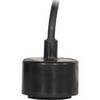
CA200B-5S 200kHz Rubber Coated Transducer for 1kW Units
-
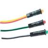
8167 Amber LED Indicator Light - 230VAC (EU)
-
ME-AGS-S - Automatic Gen Start Module, Stand Alone
-
Cat6a Ethernet Cable | 1ft | Red | Network | 10 Gigabit
-
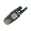
RINO 120 - Hiking GPS receiver / two-way radio - Monochrome