NA-M024 SD Card Format US West Coast and Haw
Model: NA-M024 Brand: C-Map
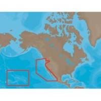
NA-M024 => USA West Coast and HawaiiCoverage of the Pacific Coast of the United States, including all of the coasts of California, Oregon and Washington. Coverage of Baja California and Mexico down to Puerto Vallarta. Detail of the Columbia River, Sacramento River, Willamette River. Snake River and San Joaquin Rivers are also included. Full coverage of Puget Sound and the San Juan Islands up to Point Roberts is also included. Additional coverage of the Hawaiian Islands out to Midway and Johnston Atoll is also included. « less
Product Specification
-
Universal Product Identifiers
Part Numbers: 30147, CMANAM024SD, M-NA-M024, NA-M024-SD, NA-M024SDCARDGTIN: 000000165847, 00686074002746
Related Products
-
1100 Series 1197c SI Combo CHO - Marine Chartplotter - 10.4" color - 800 x 600
-
Thru-Hull Speed/Temp Trans Plastic E66071
-
010-C0738-10 Bluechart G2 HUS400SWalkers Cay to Exuma Sound
-
75ft 24AWG Cat6a 500mhz Stp Ethernet Bare Copper Network Cable - Blue
-
Bronze Seacock, 3/4 Inch Adapter, Straight 0835005PLB
-
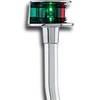
Lopo Light Masthead (3nm)
-
Wiring Device-Kellems Hbl61cm25 Marine Adapter 3d963
-
/ Quicksilver 807097T Connector
-
M260 in Hull 1kW Transducer No Connector
-
Marine -9-72652 PLUG,DRAIN - Magnet
-
Stowaway Combination Pole Light without Base
-
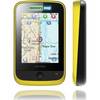
Memory Map Adventurer 3500 GPS - Marine Plus OS Mapping, Yellow/Black