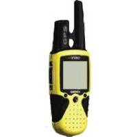
RINO 110 - Hiking GPS receiver / two-way radio - Monochrome - 160 x 160
Model: 110 Brand: Garmin
The Rino 110 is a GPS-enabled handheld that integrates radio functionality to provide two-way communications. It's waterproof, can send communications up to five miles (using GMRS channels), and can "beam" your exact location to another Rino user within a two-mile range (on the FRS spectrum) using "Position Reporting". And because the Rino 110 has standard FRS capabilities, you can talk to friends or family who own conventional FRS radios. « less
Product Specification
-
General
Product Type: GPS receiver / two-way radioRecommended Use: HikingPreloaded Maps: WorldwideReceiver: 12 channelInterface: Serial, NMEA 0183, RTCM SC-104 DGPSCompatible Software: MapSource Points of InterestGrids: UTM, MGRS, Lat/Lon, UPS, Loran TDs, MaidenheadSBAS: WAASDGPS: DGPS readyAntenna: ExternalAccuracy: Position - 49 ft Velocity - 0.16 ft/sec Position - 10 ft - 16 ft ( with DGPS ) Velocity - 0.16 ft/sec ( with DGPS ) Position - 10 ft ( with WAAS ) Velocity - 0.16 ft/sec ( with WAAS )Update Rate: 1/secondInternal Memory: 1 MB flashFeatures: Downloadable POIsFirst Seen On Google Shopping: November 2003 -
Display
Type: LCD - monochromeResolution: 160 x 160 -
Acquisition Times
Warm: 15 secCold: 45 sec -
Navigation
Waypoints: 500Tracks: 20Routes: 20Waypoints per route: 30Trip Computer: TracBack, average speed, maximum speed, trip timer, trip distance, sunrise/sunset times, sun/moon positions -
Connections
Interfaces: Serial - RS-232 -
Battery
Type: AA typeRequired Qty: 3Run Time (Up To): 28 hours -
Miscellaneous
Protection: WaterproofWaterproof Standard: IPX7Included Accessories: Wrist strap, belt clip -
Dimensions & Weight
Width: 2.3 inDepth: 1.6 inHeight: 7 inWeight: 8.3 oz -
Environmental Parameters
Min Operating Temperature: 5 °FMax Operating Temperature: 158 °F -
Universal Product Identifiers
Part Numbers: 010-00270-00, 010-N0270-00, 110GTIN: 00689076139793, 00753759031947, 00753759040925
Related Products
-
Sd/630P+ E Gulf of MX Plat+On M155Sd
-
010-C0751-10 Bluechart G2 HAF451SNamibia to Knysna Sa Data
-
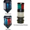
40400-7 S40 Masthead Navigation Light 12v/25w
-
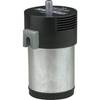
10102 Air Horn Compressor, 12VDC
-
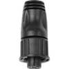
010-11081-00 - NMEA 2000 Terminator, Female
-
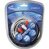
Audiopipe Ip2rca3 2 Ch Marine Oxygen Free RCA Cable 3 ft 2 Channel
-
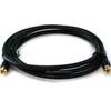
6ft RG6 (18AWG) 75OHM, Quad Shield, CL2 Coaxial Cable with F Type Connector - Black
-
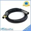
6ft Premier Series XLR Male to XLR Female 16AWG Cable (Gold Plated) [Microphone & Interconnect]
-
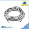
30ft 24AWG Cat5e 350MHz UTP Bare Copper Ethernet Network Cable - Gray
-
FA58976-1 - Connector assy , NLA Mercury Marine
-
HBL63CM65 Male Plug 50A 125/250V Ship-to-Shore
-
GPS receiver remote control - Radio