The nautical chart [Book]
Coy is a suspended sailor with time on his hands, a mariner without a ship. While attending a maritime auction in Barcelona, he meets a beautiful woman who immediately captures his imagination. Tnger Soto, who works for the Naval Museum in Madrid, is obsessed with the Dei Gloria, a Jesuit ship sunk by pirates in the seventeenth century, and now-she hopes-resting on the bottom of the sea off the southern coast of Spain. Tnger uses her considerable manipulative skills with men and her expertise with documents, atlases, and nautical maps to chart the search for lost treasure. Coy is quickly drawn into the search, and before long finds himself falling in love. Along with El Piloto, the world-wise old man of the sea whose sailboat will carry this adventurous crew, they seek their fortune together. Or do they?As these lively characters follow the course of past sailors, their own journey becomes perilous. Are there secrets dwelling in the depths of the sea? And what of the depths of the heart? This highly intelligent and meticulously plotted novel combines the richness of atmosphere we have come to expect from Prez-Reverte with the romance and mystery of the sea found in the novels of Melville, Conrad, and O'Brian. An unforgettable adventure."The master of the intellectual thriller."--San Francisco Chronicle « less
Product Specification
-
Authors: Arturo Pérez-Reverte, Margaret Sayers PedenPages: 466Format: hardbackPublication Date: August 4, 2001Key Terms: Carpanta, Tanger, brigantine, xebec, nautical chart, Cadiz, Jesuits, Piloto, Mazarron, Felix von Luckner, Berber, Gibraltar, Kiskoros, corsair, sextant, Red Rackham's Treasure, blued steel, Society of Jesus, Palau, Barcelona
-
Universal Product Identifiers
ISBN: 0151005346GTIN: 09780151005345
Related Products
-
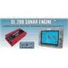
SE200C Sonar engine with 2 Thru Hull Transducers U1-200C-00E 1200c00e
-
Package(C120W, DSM300G Sounder, RA1048D 4KW 48 Inch HD Digital Open Array Radar & 15m Radar Cable)
-
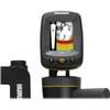
Fishin' Buddy 140c - Fishfinder - portable - included transducer - single-beam
-
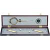
319 Elegant Navigation Set
-
Cdr10 Digital Chart Kit Pr and US VI
-
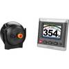
GHP 20 Marine Autopilot System for Steer-by-Wire
-
Marine Naviled 360 All-Round Navigation Light
-
75ft 24AWG Cat5e 350MHz UTP Bare Copper Ethernet Network Cable - White
-
3ft 30AWG High Speed HDMI Cable - HDMI Connector to HDMI Mini Connector - Black
-
6ft Premier Series XLR Male to RCA Male 16AWG Cable (Gold
-
3ft USB 2.0 A Male to A Female Extension 28/24AWG Cable (Gold Plated)
-
COUP30B 30 Amp Watertight Connecting Coupler Assembly