Waterproof Chart Kit - Long Island Sound #WPB0325-03
Model: WPB0325-03 Brand: Maptech
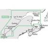
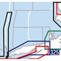
Waterproof Charts w/ Companion CD WPB0325 325: Long Island Sound NEW LAYOUT. 20 MORE PAGES. The entire Sound to Block Island and Point Judith. 10 overview charts and 50-plus harbor insets. 48 pages, 200 GPS waypoints, pre-plotted courses, ramps and 500 marinas. 12 x 17, scales 1:89,000 with insets. Product Overview These easy-to-use, compact chart books are ideal for Day-Sailors, Fishing Boats, and Trailer Boats. They measure 12 x 17 (24 x 17 when open) and are made of waterproof, tear-resistant synthetic paper that will withstand the elements. GPS Ready New features make Waterproof Chartbooks easy to use with your GPS. Most charts include one-minute lat./long. grids to make vessel positioning a breeze, and major navigation aids are identified with named GPS waypoints. Small and Large-Scale Charts Waterproof Chartbooks include small-scale, wide area charts as well as large-scale « less
Product Specification
-
Universal Product Identifiers
Part Number: WPB0325-03
Related Products
-
SP-80L Autopilot with 18 Cu Inch Pump & Linear Feedback for Inboard Outboard & Sterndrive c10441
-
Target Detection by Marine Radar [Book]
-
LMB-A3 Self Leveling Radar Mount-LMB-A3
-
NT+ - St. Lawrence River and Approaches NA-C202
-
Marine Navigation: Celestial and electronic [Book]
-
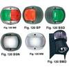
European Style Navigation Lights, Red Side Light, Black Perko
-
VGA Male to Male Cable 15 ft. CL2
-
743 HPDB50 M/CN50 M SCSI Cable , 25pr - 1.5ft
-
Amber LED, 12 Volt DC, 8033
-
000-0022-17 LHR-80 DSC VHF/GPS Radio
-
RINO 130 - Hiking GPS receiver / two-way radio - Monochrome - 160 x 160
-
Matrix 97 Combo CHO - Marine Chartplotter - 5.6" color - 320 x 240