010-C0748-10 Bluechart G2 HAF002RSouth Africa Data Card
Model: 010-C0748-10 Brand: Garmin
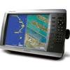
Detailed coverage of the coast of southern Africa from Namibe, Ang. to Angoche, Moz., including the South African cities of Cape Town and Port Elizabeth. Includes detailed coverage of Durban S. Af. and Maputo, Moz. Also includes detailed coverage of the Tristan da Cunha Group, the island of St. Helena, and the Prince Edward Islands. See your surroundings more clearly with BlueChart g2 data. With BlueChart g2, you'll get detailed marine cartography that provides convenient viewing of nautical content. BlueChart g2 allows you to see your vessel's precise, on-chart position in relation to naviads, coastal features, anchorages, obstructions, waterways, restricted areas and more. You will also have access to detailed mapping capabilities that include Safety Shading , Fishing Charts , smooth data transition between zoom levels, harmonious transition across chart borders, and reduction of chart discontinuities. « less
Product Specification
-
Universal Product Identifiers
Part Numbers: 010-C0748-10, 10804557, 35577GTIN: 00753759089658
Related Products
-
010-C0728-10 Bluechart G2 HUS027RHawaiian Islands Mariana
-
Chart No. 1 Nautical Chart Symbols Abbreviations and Terms: Spiral-Bound [Book]
-
SOLARA-DSC Black Solara Compact Fixed Mount VHF 2-Way Marine Radio - Black
-
y94556 Compact Hand-Held JIS8 Submersible Marine Radio
-
2897.91 FBRS 2897 Battery Replacement Service - PLB-30
-
9403 Replacement Lamp for RCL-75, 55W, 12V
-
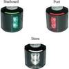
Series 43 White LED Navigation Light Port
-
Cat6a Ethernet Cable | 1ft | Orange | Network | 10 Gigabit
-
Series 50 Classic Stainless Steel Navigation Lights
-
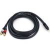
10ft Premium 2.5mm Stereo Male to 2rca Male 22AWG Cable 5607
-
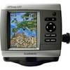
GPSMAP 420 - Marine GPS receiver - 4" color - 240 x 320
-
GPSMAP 4010 Plotter with GPS Antenna 010-00690-00