Sea Sense
-
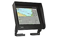
River ECDIS 1CSOENKI/ECDIS 270 1D
1CSOENKI/ECDIS 270 1D is a universal electronic chart system that allows ECDIS (Electronic Chart Display and Information System) equipment to be used as conventional for marine vessels carrying out international routes.AAElectronic Chart Display and Information System 1CSOENKI/ECDIS 270 1D is intended for installation on marine vessels, river boats and vessels of mixed type (river-sea). The advantage of the equipment is functionality designed for sea and river vessels with a rapid transition from the sea operating mode to the river, and vice versa.AThe 1CSOENKI/ECDIS 270 1D system can be installed on marine vessels and connected to the equipment in both single execution and as a part of the integrated navigation system. The ability to duplicate the chart and navigation information replaces paper charts in the vessel operation, which is regulated by the International SOLAS Convention. The equipment supports integration of all marine vessel navigation information and operational decisions concerning marine navigation safety issues.AThe search in the menu can be made in both English and Russian languages.AFunctionalityAAThe electronic chart system 1CSOENKI/ECDIS 270 1D includes:AA Electronic Chart Display and Information System;A Route planner;A Route monitoring and tracking of objects in the vicinity of the marine vessel;A Alarm system;A Correction and updating of electronic map charts and chart collection;A Navigation equipment integration system;A Navigation sensor control system;A Backup and recovery of navigation information record.AA 1CSOENKI/ECDIS 270 1D equipment provides a range of functions specifically for operation on inland waterways (IWW):AA Switching navigation mode from sea going (speed in knots, range in miles) to river going conditions (speed in km/h, range in km) and vice versa in the real navigation mode;A Recording of track data; built-in audio module enables prompt recording of the waypoint information with playback at a time convenient for navigator;A Ability to quickly chart all available river markers on electronic charts in manual electronic correction mode;A Calculation of the point of approach to the vessel on the curved river sections according to AIS information from oncoming or overtaken (overtaking) vessel;A Towing of objects with the addition of the object contours on the screen over bow, aft, starboard or port side;A Logging on the main panel the value of kilometre performance and of the distance from it to current location of the vessel.
-
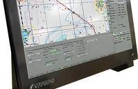
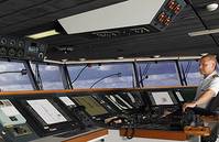
Navi-Sailor 4000 ECDIS
PurposeECDIS is a computer-based navigation information system compliant with International Maritime Organization (IMO) regulations and can be used as an alternative to paper nautical charts. An ECDIS system displays the information from electronic navigational charts (ENC) and integrates position information from the Global Navigation Satellite System (GNSS), gyrocompass, speed log, other navigational sensors, radar and automatic identification systems (AIS). Transas delivers a full range of type-approved ECDIS solutions that can be stand-alone or part of the Integrated Navigation Systems or Multifunctional Display i.e. Radar, Conning, Alarm Management, Track Control in one workstation. Transas ECDIS provides easy and unique possibilities for customization.Standard/Standard+ - Premium/Premium+Each system includes a carefully selected range of standard features, with an extensive range of additional hardware and software options. So whether you 19re just beginning your ECDIS journey or seek the ultimate level of information at your fingertips, Transas offer something for every ECDIS user.Advantages The world 19s number one ECDIS User friendly navigation tool Most evolved ECDIS on the market Flexible configuration 4-level ECDIS solutions to suit all customers MFD functionality and network capability Consistent graphic user interface (GUI)
-
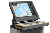
Navi-Sailor 4000 ECDIS MFD Premium/Premium+
Every Transas MFD workstation (WS) can be equipped with a standard set of software such as ECDIS, Radar, Conning, Chart Assistant utility and SPOS weather module giving the mariner the ability to switch between applications at the touch of a button. All the aforementioned applications are running simultaneously as part of the Multifunction Display.FunctionalityNavi-Sailor 4000 ECDIS MFD is available in two packages: Marine LED Display Transas RS6 computer Transas ES6 Keyboard Transas ES6 Trackball Navi-Sailor 4000 ECDIS Software Basic ECDIS Functions Docking Mode Reference points for mooring operations Dual Chart Panel Left Chart Panel (conning) Special Purpose Objects Target Simulator Trial Maneuvering Ports DB Quick distance calculator Configuration of Local Workstation New GUI and Bridge Configuration (June 2012) AIO 13 Additional information Overlay Additional Chart Formats Additional Route Planning Functions Additional Sensors AIS, ARPA and Target Management ARPA B (second ARPA) Target simulator Tides & Currents Playback Maps (User Charts) Navtex Interface Premium+ pack brings the following additional advanced functions: Trial Maneuver Precise Nav Tools 13 Predictor/Route AIS RDVZ/CHL Advanced planning functions E-Log book Navi-ConningFor both Premium and Premium+ an extensive range of additional hardware solutions and software options are available.AdvantagesSafe Navigation and Easy OperationProvides all the information you need, via a user-friendly and intuitive menu system.Information System and Decision SupportA continual flow of information for presentation of the crucial and most needed navigational information and objects.Choice and CustomizationNew and practical options enable system customization, including multiple operation modes with charts in up to 7 different formats.Sensor IntegrationConnects all available onboard navigation data sensors and systems, such as: two positioning systems, gyro, log, two ARPAs, AIS, echo sounder, autopilot, navtex and more. Planning and Forecasting Includes powerful tools for passage planning, weather routing and calculation, and environmental tide and current databases. Weather forecasts, with the optional SPOS weather and route planning tool, are integrated with NS 4000.SavingsDirect effects on fuel consumption, voyage times & work time.Integration Navigator-friendly environment for One Man Bridge operation reduces workload and stress; Clear and consistent man-machine interface for intuitive and convenient operation; Enhanced functional integration of navigational data; System redundancy: all functions of ECDIS, Radar and Conning can be available on all MFD 19s onboard; Palettes synchronization in all 3 applications; Sensor redundancy and double network ensures data integrity and reliability for network configuration; Intelligent and efficient alarm management; Simultaneous Loaded Route monitoring in ECDIS, Radar & Conning; ECDIS Master Station status changeover to any MFD station; Distribution of radar pictures from all available radars within MFD network; Chart correction, route and user database synchronization at all workstations and applications; Order charts, charts corrections and weather forecasts online via ship communication station protected by firewall.
-
-
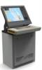
Navi-Sailor 4000 ECDIS Standard/Standard+
Standard and Standard+ are the entry-level system from Transas and meet all IMO and SOLAS ECDIS regulations. You can benefit from advanced technology in a simple package along with the quality and service expected from Transas. Navi-Sailor 4000 ECDIS is a navigation information system that displays full positional information from navigation sensors on electronic navigational charts. The system is designed to assist the officer in charge of the navigational watch (OOW) in route planning and monitoring.Functionality 24 1D Marine Panel Computer; Transas ES6 Trackball; Navi-Sailor 4000 ECDIS Software; Basic ECDIS Functions.The Standard+ pack brings the following additional planning and information functions: Additional Chart Formats; Additional Route Planning Functions; Additional Sensors; AIS, ARPA and Target Management; Tides & Currents; Playback; Maps (User Charts); Navtex Interface.An extensive range of additional hardware solutions and software options are available for both Standard and Standard+.
-
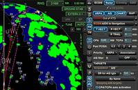
Navi-Radar 4000
Transas made use of proven solutions in combination with advanced technology to develop Navi-Radar 4000AAPurposeANavi-Radar 4000 uniquely combines radar information, navigational charts, ENC safety parameters, targets, user-maps, routes and tools for decision support, which all ensure safer navigation.AWith Navi-Radar 4000, chart layers can be individually configured, avoiding a cluttered radar display.AAFunctionalityAA Pre-calculated motion vectors: Even before the operator acquires a target, Transas Navi-Radar 4000 already selects potential targets and provides you with instant vector and object data.A Target association: Built-in filters can associate any AIS and ARPA target to provide reliable, real-time data, selected by the operator.A Filtering lost targets: In heavily trafficked areas, focus is key to avoiding dangerous situations. Operator-defined target filters warn you only when necessary.A Trial Manoeuvres and Curved Heading Line: Real-time calculations and presentation strengthen any decision made by the officer.A Chart Radar: Efficient multi-loading and display of electronic charts where ENC/SENC or TX-97 charts can be presented as an underlay simultaneously with individually created MAPs.AAAdvantagesAA A true chart radarA User-friendly and consistent GUI throughout the Transas 1CMultifunction Display 1D (MFD) navigation systems series - e.g. ECDIS, Chart Radar, ConningA Full MFD integration with high configuration flexibilityA 24/7 telephone and e-mail support with local service stations in all major portsA Remote (online) service, support and maintenanceA Highly cost-effective and flexible combinations with ECDISA Easy and affordable upgradesA Supplied with Transas Admiralty Data Service (TADS), which offers the best available charts and digital services
-
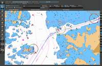
Navi-Planner 4000
Navi-Planner 4000 sets a new standard for safe and efficient voyage planning. This innovative solution from Transas provides a single access point for all information needed for every step of the navigation process When developing the Navi-Planner 4000, Transas worked closely with oil company vetting-inspectors, ship owners and navigation officers. The result is a tool which makes voyage planning easy for navigators and efficient for ship owners. Navi-Planner 4000 complies with IMO Resolutions (IMO 1.916(22) Guidelines for the recording of events related to navigation and IMO A.893(21) Guidelines for Voyage Planning).PurposeNavi-Planner 4000 is recognized as the ECDIS markets most powerful charts management application, and also a set of databases, applications and services intended for voyage planning. Suitable both onboard as a 19back of the bridge 19 application, and ashore as a management tool Navi-Planner 4000 software creates a voyage plan using an electronic route editor, including: Port to port planning of a complete voyage plan AtoBviaC auto routing Under Keel and Over Head Clearance Route checking Reference point selection Reporting points Warnings along the route Chart listings for both (S)ENC and paper charts Detailed voyage plan reports Route export/import Integration with Navi-Sailor 4000 ECDIS Online correction service for paper charts and publications via TGT ServicesApplications and ServicesQuick Route with AtoBviaC distance tables 1CAtoBviaC distance tables 1D is a unique and powerful tool for basic route navigation planning. The routes are based on BP Distance Table and can be used for quick distance calculation, as a good tool for chart selection for (S)ENC Pre-licensing and as a basis for detailed route and voyage planning with Navi-Planner. 1CAtoBviaC distance tables 1D contains virtually thousands of alternate routes and a set of route calculation rules that can be set on/off by the navigator when setting up the route calculation.Weather FunctionalityThe Weather Functionality in Navi-Planner is a service to assist the mariner on board in making the best decisions with regards to voyage planning in relation to weather conditions.Advantages of onboard weather routing: Fuel and speed optimization Safety of crew and cargo Situational awareness Costs for meteorologists on shore are reduced Reduced administration onboard and in the officeThe weather data is supplied by Meteo Consult, a meteorological office that prepares a complete set of accurate weather information for standards ocean regions and coastal waters.The data includes air pressure, wind and wave forecasts but also tropical storm forecasts, temperatures, precipitation, ice limits and much more.Chart ordering and managementTransas offers a unique way of ordering and handling charts thru Navi-Planner. It can either be used for pre-licensing charts or as a Pay as you sail (PAYS) service. If pre-licensing is used, selection of charts to order can easily be made by a created route or a route loaded from the AtoBviaC auto routing functionality. The operator can select whether he wants to receive the license/permits only or receive the complete chart content from the server. During the preparation of the order a selection of license period can be made and the approximate cost of the order will be indicated.Once the charts are received and installed, Navi-Planner will display a status report and thensynchronize the data to any other Workstation within the network.If PAYS is used, a license holding all available PAYS SENC/ENCs is used and only charts that have been used for navigation will be charged.Chart correction and managementAs part of the chart management functionality in Navi-Planner, chart corrections can be ordered, installed and recorded both for (S)ENC 19s and paper charts. It is imperative for the Master to always have full control and overview for the vessels chart holdings and to be able to show this to authorities and inspectors.As Navi-Planner operates with the Transas Chart Server directly or via email it offers the easiest way to access updates for charts used onboard.Detailed waypoint and voyage planningTransas Navi-Planner is as very powerful route planning tool. It is capable of everything from basic and simple route creation to full 1Ctrack control level C 1D planning as well as Route checking and 1CUnder Keel Clearance 1D (UKC) calculations based on set ships and safety parameters.The main parts and functionality for route planning are for route geometry, schedule, additional information along the route as reference points, and metrological as well as hydrological data Routes, waypoints, Cross Track distances (XTD) and reference points can be created and edited either graphical or tabular. Route legs can be selected individually to be Rhumb-line Great-Circle based on WGS-84. Schedules can be calculated with or without speed limits for each route leg and including surface and tidal currents in the calculation.Paper chart correctionsDid you know that Navi-Planner 4000 is not only capable of managing electronic charts and publications as part of your passage planning but also paper charts and paper publications. Within the program you can easily import your complete inventory or manually make a selection of paper charts held onboard. Navi-Planner can then directly connect to the Transas chart server ashore to gather all outstanding Notices to Mariners. You will get a clear overview of the status for your paper charts and any paper chart that may be used during your next voyage will automatically be listed in the passage plan, very easy and very safe.Piracy Information OverlayTransas 18Piracy Information Overlay 19 brings you credible piracy intelligence from recognised sources around the world. Using Navi-Planner, the piracy events for the last 365 days are available to view 24/7 as an information overlay to complement your existing company account features. Piracy Information Overlay provides the user with up to date information, essential for planning avoidance measures when travelling through a potential piracy area. The PIO data service is automated and updated at a minimum of 24 hour intervals.Advantages The market 19s fastest and most powerful chart management application Everything you need for voyage planning and navigation management Digital services managed in one application Built-in paper chart and publication corrections Full voyage planning, port-to-port and berth-to-berth Developed through co-operation with customers and authorities Made to support ISM procedures and bridge administration
-
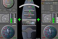
Navi-Conning
Navi-Conning is a software and hardware system, which is intended for the processing and recording of parameters supplied via different channels from external sources of information.The Navi-Conning system will considerably simplify the work of watch officers by permanently providing valid information on the operation of ship systems.FunctionalityA standard Navi-Conning system provides 4 base screen views: Current ship coordinates, course and speed; Rudder blade position; information from main engine room, telegraph repeater, etc.; Status of navigation lights; Sounder readings, wind and route.Advantages Processing of parameters supplied via different interfaces from external information sources and their presentation on a single screen; Reception of information in network in digital and analogue formats provides base screen views and makes it possible to use custom-made individual screens; Extendable measurement unit database; Internal Recording functionality.
-
Navi-Sailor 4000 Pilot
Transas Navi-Sailor 4000 Pilot system has been developed specifically for the needs of pilot organizations around the world. With a carefully considered range of support functions, the system is designed to assist pilots in their daily routine helping them to maintain efficiency of operation before, during and after pilotage.FunctionalityPreparation Transas own Chart Assistant/Navi-Planner software specially designed to assist with all forms of chart administration, including: installation/updates, chart data base status etc. User-friendly route planning functions 13 Ships particulars can be set prior to departure or updated whilst onboard Saving the pilot 19s personal settings and hot-key functionsDuring pilotage and mooring Bluetooth Pilot Port Repeater allows AIS data to be wirelessly transmitted from a ship 19s AIS directly to the pilot 19s laptop wherever it is located on the bridge Advanced route monitoring and display Built-in maneuvering predictor and Docking Mode/Display Navigator display with key information easy to read for the pilot Anchorage bearing and distance presentation Alarm management with ability to turn off/mute alarms and warnings Ability to send data from laptop to PDA with 1CDocking data display 1D
-
Navi-Sailor 4000 ECS MFD
The Navi-Sailor 4000 ECS Multifunction Display is based on the certified Navi-Sailor 4000 ECDIS, which meets the requirements of the latest IMO, IHO and IEC performance standards and resolutions. Navi-Sailor 4000 ECS MFD is the ideal solution for ship owners requiring professional and reliable navigation, but where a certified ECDIS is not required.AATransas Navi-Sailor 4000 ECS MFD is a navigation system that displays full positional information from navigation sensors on electronic navigational charts. The system assists the officer in charge of the navigational watch (OOW) in route planning and monitoring. Four main tasks can be operated on every navigational station: Navi-Sailor4000, Navi-Radar 4000, Navi- Conning 4000 and Alarm Monitoring System.AAFunctionalityAASupported chart formats and main chart functionalities:AA Vector chartsA Raster chartsA Navi-Planner chart handling toolA Chart ControlA Charts Manual updateAANavigational tools:AA Alarms and warningsA ERBL/EBL/VRMA North Up, Head Up and Course UpA Quick distance measuring toolA True/Relative MotionA MOBA Docking ModeA Dual chart panelA Manually fix positionA Left information panelAAWorking with Routes:AA Route Planning CapabilityA Multiple RoutesA ScheduleA Route MonitoringA Route Converting CapabilityA Route CheckingA SAR operationsA Route PrintoutAALogging Functions:AA System LogbookA Ships TrackA Target Data and their statusA Radar OverlayA PrintoutA PlaybackAAUtilities:AA Data tool 13 FileA System ConfigurationA PlaybackA Transas Integrator
-
Transas NW-4000 VDR/SVDR
Transas NW-4000 VDR/S-VDR is intended to record vital information related to a vessel 19s operation. It is a type-approved product, which meets and exceeds IMO and IEC requirements. FunctionalityNW-4000 is used for safe collection and storage of voyage data such as ship position, movements, physical condition, bridge commands etc. for a defined time period, with an available playback function
-
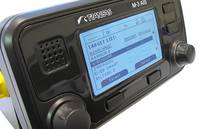
Class A M-3 AIS Transponder
The Transas M-3 AIS transceiver is fully integrated Class A product which offers exceptional performance, usability and reliability, with plug and play compatibility with most display (ECDIS & Plotters) and sensor systems. The M-3 Class A is fully IMO compliant and certified for worldwide use by SOLAS vessels and certified as compliant with the relevant EU Inland waterway regulations for vessels operating on regulated Inland waterways.Functionality Standard AIS functionality High quality, low maintenance 1Cone unit 1D AIS Transponder with built in Minimum Keyboard Display (MKD) Long range tracking capabilities Display of AIS messages from aids to navigation (AtoN) Safety Related Messages (SRM) and Short Message Service support Pilot plug integrated in display unit Three modes of operation: Autonomous and continuous mode for operation in all the regions Assigned mode for operation in an area subject to a competent authority A polling or control mode where the data transfer occurs on response to interrogation of vessels or competent authorities Integration with external (D)GPS receiver, gyro compass, speed log, ECDIS/ECS and radar Input and output communication ports for integrated bridge systems Channel management capability (regional AIS frequencies) Easy upgrade 1W output power option for hazardous cargo handling AIS Class B 1Ccarrier sense 1D message support Bracket or flush mounting
-
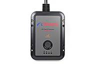
Class B M4-N AIS Transceiver
M4-N Class B is a fully certified and type approved AIS Transceiver for global use in accordance with published AIS standards. FunctionalityThe Transas Automatic Identification System (AIS) Class B receiver and transmitter unit is low cost, but high performance product designed especially for fishing vessels, passenger ships, coastguard, leisure and workboats.The compact AIS Class B unit is suitable for a variety of applications within the AIS environment.Advantages Small and tough. M4-N 19s IPx7 shell has been developed to be extremely tough and resistant to even the harshest environments. Integrated GPS antenna. Simple installation is achieved with M4-N 19s internal GPS antenna reducing installation cost and time. Plug and play. Simple and quick setup is achieved with MNEA 0183, NMEA 2000 and SUB plug and play capabilities.