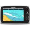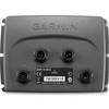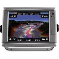
010-00749-01 - GPSMAP 7212, 12 Tchscrn MFD, Coast Map
Model: 010-00749-01 Brand: Garmin
These premier touchscreen GPS/Chartplotters all include an external GPS antenna and a worldwide, satellite enhanced basemap. In addition, the 7200 models include preloaded BlueChart g2 maps of the U.S. coastal areas, including Alaska, Hawaii, and the Bahamas. Additional maps can be easily added with the SD card slot. All units allow for the addition of sonar, radar, weather, and more. Powerful microprocessors provide ultra-fast map redraw and refresh rates with near real-time data to guide you. Live video feeds are easy with the video inputs for cameras, night vision, etc. and output options for remote display. For additional enhanced features these units accept optional BlueChart g2 Vision cards with 3-dimensional perspectives, high-resolution satellite images, Auto Guidance, and more. Includes: Waterproof (IPX7), High-sensitivity, external antenna, NMEA 0183, NMEA 2000 and PC video monitor input/outputs, SD? « less
Product Specification
-
Universal Product Identifiers
Part Numbers: 010-00749-01, 11068558, 37772, GAR0100074901GTIN: 00753759099367
Related Products
-
T70023 C97 Multifunction Display w/Sonar - European Charts
-
Max AU-M222 W63 New Zealand Chatham-MAX
-
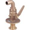
0834007PLB Seacock w/Curved TP 1-1/4in
-
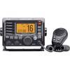
M504 Black VHF Radio
-
010-11053-00 ECU, Electronic Control Unit for GHP10 Autopilot
-
120-53 EP-80RTH Thru-Hull Water Temperature Sensor
-
3ft eSATA + USB to Esatap Cable - Black
-
GC7267 Stranded Cat6 RJ45 Plug (100-Pack)
-
MARE-003 - Adapter, Yamaha Cmnd Link to Micro Male
-
8.0 Sbeg Generator
-
SeaTalk Cable High Speed Network C16533
-
GPSMAP 526s - Marine Chartplotter - 5" color - 480 x 640