010-C0772-20 Bluechart G2 HXEU014RItaly Adriatic Sea Microsd/sd
Model: 010-C0772-20 Brand: Garmin
GARMIN BLUECHART G2 HXEU014R ITALY ADRIATIC SEA MICROSD & -- 35618 -- HXEU014R Covers:Includes all of the Adriatic Sea and extends south to Siracusa, Sicilia and Gulf of Arcadia, Greece. Includes detailed coverage of Lago Maggiore, Lago d'Iseo, and Lago d'Garda in Italy.
Product Specification
-
Universal Product Identifiers
Part Numbers: 010-C0772-20, 10805042, 35618, CW-35618GTIN: 00753759091682
Related Products
-
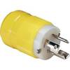
4721CR Marine Electrical Plug 15-Amp Locking
-
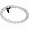
Radar 25M Split Power Pedestal Cable-Radar
-
Ultra Marine Chart Caddy, Teak
-
010-C1024-10 Bluechart G2 HUS401SBermuda Data Card
-
Adventure Medical 0115-2000 Kit Marine 2000
-
TimeZero Odyssey Navigation Software
-
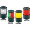
Navigation Light Sern #0200SNTDP1
-
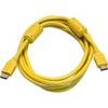
10ft 28AWG High Speed HDMI Cable w/Ferrite cores - Yellow
-
F-Splice-CP/GH-01 Connector for RG-6U Cable
-
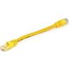
Yellow Six Inch Category 5 Enhanced Cat 5e Ethernet Network Cable .5
-
FCF000117A Teak Fresh Air Vent Kit for 5,000 / 9,000 BTU Units
-
010-00772-01 GPSMAP 526S Marine GPS Receiver