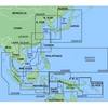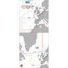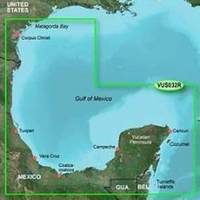
BlueChart g2 Vision - Southern Gulf of Mexico - Maps
Model: Brand: Garmin
BlueChart g2 Vision offers the same rich detailed charting of BlueChart g2 to help you get the most out of your unit. In addition, g2 Vision features a growing database of high-resolution satellite imagery, above and below the water 3D perspective, auto guidance technology, aerial photographs for real world reference and coastal roads with points of interest. This product features detailed coverage of the Gulf of Mexico from Matagorda Bay to Belize City, including Corpus Christi, TX, Veracruz, Mex., the Bay of Campeche, Cancun, Mex., and Cozumel, Mex. « less
Product Specification
-
General
Product Type: MapsDistribution Media: SD Memory CardFirst Seen On Google Shopping: May 2007 -
Compatibility Information
Designed For: Garmin GPSMAP 4008, 4012, 420, 4208, 420s, 4212, 430, 430s, 430sx, 430x, 440, 440s, 440sx, 440x, 450, 5008, 5012, 520, 5208, 520s, 5212, 525, 525s, 530, 530s, 535, 535s, 540, 540s, 545, 545s, 550, 550s, 555, 555s -
Universal Product Identifiers
Part Numbers: 010-C0733-00, Southern Gulf of MexicoGTIN: 00753759069131, 00781573940213
Related Products
-
FR8252-6 Open Array Radar
-
8264; Map-Clearlake/Lake Berryessa
-
ST1000 Plus Tiller Autopilot Tiller Autopilot St2000+ A1200
-
MapSource BlueChart - Hong Kong/South China Sea - Maps
-
Max EW-M009 MW2 Atlantic European Coasts-MAX
-
XGPS150 - Marine, hiking, automotive, cycle, golf, running GPS receiver
-
Double Lens, Side Navigation Lights, 120V Volts, 1164 Series, Red
-
1.5ft Premier Series XLR Female to 1/4inch TRS Male 16AWG
-
6ft A to Mini-B 8pin USB Cable w/ Ferrites for Nikon Coolpix
-
Fiber Optic Cable, LC/ST, Multi Mode, Duplex - 3 Meter 2623
-
SBBL Switch Box 2 Ducers1 Unit Blue Connector
-
000-10516-001 HDS-5 Gen2 Lake Insight w/o Transducer