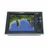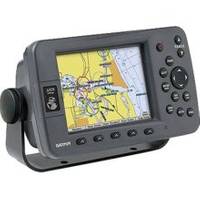
GPSMAP 3205 - Marine GPS receiver - 5" color - 640 x 480
Model: 3205 Brand: Garmin
Plug into the power of the Garmin Marine network with the Garmin 3200 series. Rugged, waterproof, and easy to install, these chartplotters come preloaded with Garmin's detail-rich marine cartography utilizing BlueChart g2 technology. The GPSMAP 3205 offers a mid-range option for boaters wanting the benefits of a seamless plug-and-play system. It has a 5-inch color display, and it can serve as a standalone plotter or network with other MFDs and sensors to deliver XM weather, radar and sonar. Unlike its 6- and 10-inch counterparts, this one does not offer a remote control, VGA output or video input options. However, it does provide full Garmin marine networking capability in a compact, budget-friendly format. Convenient soft key functions allow you to assign a feature such as map declutter to a specific key. « less
Product Specification
-
General
Product Type: GPS receiverRecommended Use: MarineReceiver: 12 channelCard Reader: Garmin Data CardInterface: Serial, NMEA 0183Included Software: Garmin Marine Point Database (Americas), Garmin Worldwide Marine BasemapCompatible Software: MapSource BlueChart g2Grids: UTM, MGRS, Lat/Lon, User, Loran TDs, MaidenheadSBAS: WAASAccuracy: Position - 49 ft Velocity - 0.16 ft/sec Position - 10 ft ( with WAAS )Update Rate: 1/secondFeatures: Backlit keypad, alarm, XM weather supportFirst Seen On Google Shopping: February 2006 -
Display
Type: LCD - colorDiagonal Size: 5"Resolution: 640 x 480Display Illumination: Yes -
Acquisition Times
Warm: 15 secCold: 45 sec -
Navigation
Waypoints: 4000Tracks: 15Tracklog Points: 10000Routes: 50Waypoints per route: 300Trip Computer: Sunrise/sunset times, sun/moon positions -
Connections
Interfaces: Garmin Marine Network Serial -
Miscellaneous
Design Features: Rugged caseProtection: WaterproofWaterproof Standard: IPX7Included Accessories: Protective cover, mounting bracket, power/data cable -
Dimensions & Weight
Width: 7.8 inDepth: 3 inHeight: 4.7 inWeight: 1.8 lbs -
Environmental Parameters
Min Operating Temperature: 5 °FMax Operating Temperature: 131 °F -
Universal Product Identifiers
Part Numbers: 010-00526-00, 3205GTIN: 00753759053048
Related Products
-
AP5009 Autopilot with AP50, J50, Rudder Feedback RF300, HLD350
-
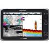
G10 10" Multifuntion Display w/Built in 2KW Sonar 40341
-
e165 15.4 Display Multifunction Coastal Chart #E70025-US
-
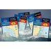
Waterproof Chart Kit - Cape Cod to Cape Ann, Mass #WPB0240
-
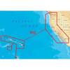
Platinum Plus US West Coast CF/912P+
-
Hydrographical Surveying. a Description of the Means and Methods Employed in Constructing Marine Charts. [Book]
-
5in Plain Bronze Door Hook
-
15ft 32AWG Mini DisplayPort to DVI Cable - White
-
50ft 22AWG 5-rca Component Video/audio Coaxial Cable (RG-59/U) - Black
-
Fuel Line Connector Mercury Female Fitting 2-Prong
-
Lumishore Thru-Hull Underwater Light - Blue - 120W
-
lian i3 System Dish Network w/Multi-Satellite Interface & Dish