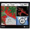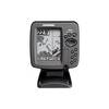
GPSMAP 545s - Marine GPS receiver - 5" color - 640 x 480
Model: 545s Brand: Garmin
This chartplotter provides the brightest, sharpest, most colorful graphics you've ever seen on a 5-inch screen. See clearly as you navigate with the 545's crisp, sunlight-readable VGA display driven by a high-speed processor. This chartplotter offers exceptional detail, fast redraw rates, and the most realistic photo-enhanced cartography ever seen in this class of fixed-mount electronics. The 545 includes detailed offshore maps with Bluechart g2 coverage of the USA and Bahamas. The 545s comes with powerful dual frequency or dual beam sonar to clearly paint depth contours, fish targets, structure, etc. It's also CANet capable, allowing sounder data to be shared with other plotter displays on your boat. « less
Product Specification
-
General
Product Type: GPS receiverRecommended Use: MarineReceiver: 12 channelCard Reader: SD Memory CardCompatible Software: BlueChart g2 VisionSBAS: WAASDGPS: DGPS readyAccuracy: Position - 49 ft Velocity - 0.16 ft/sec Position - 10 ft ( with WAAS )Update Rate: 1/secondFeatures: Optional external GPS antenna connectionFirst Seen On Google Shopping: February 2007 -
Display
Type: LCD - colorDiagonal Size: 5"Resolution: 640 x 480Features: Adjustable brightness -
Acquisition Times
Warm: 15 secCold: 45 sec -
Connections
Interfaces: Antenna -
Miscellaneous
Design Features: Rugged caseProtection: WaterproofWaterproof Standard: IPX7Included Accessories: Transom mount transducer, protective cover, mounting bracket -
Dimensions & Weight
Width: 5.9 inDepth: 2.9 inHeight: 6.4 inWeight: 1.8 lbs -
Environmental Parameters
Min Operating Temperature: 5 °FMax Operating Temperature: 131 °F -
Universal Product Identifiers
Part Numbers: 010-00602-00, 010-00602-01, 545sGTIN: 00753759066482
Related Products
-
HDS-7 Gen2 Fishfinder GPS Chartplotter 53519700
-
Canadian Charts - N amp; O, Otter passage-bonilla Island Canadian
-
3204 Lake Havasu
-
Marlan Inst Hole Cvr 2in Rd Instrument Hole Covers 530001C
-
75ft 24AWG Cat6a 500mhz Stp Ethernet Bare Copper Network Cable - Blue
-
000-10213-001 RS25 VHF Radio
-
290 Marine Navigation ROADrule Marine Navigation Aids
-
3ft 28AWG DisplayPort to DVI Cable - White
-
NSO15 Package - Monitor, Marine Processor, Remote, and SD Card Reader 41216
-
A62245 1.5m SeaTalk HS Cable Waterproof Connector
-
300 Series 365i Combo - Marine Chartplotter - 4" monochrome - 240 x 320
-
GlobalMap 6600C HD - Marine GPS receiver - 7" color - 640 x 480