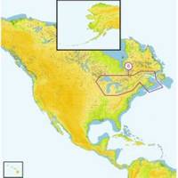
Great Lakes and The Maritimes NA-M026 c30127
Model: NA-M026 Brand: C-Map
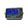
NA-M026 Great Lakes and The Maritimes MAX: The Ultimate Navigator, brings electronic charts to life. - Aids on-screen exactly as they appear through your pilothouse window. Get "at-a-glimpse" information about current strength and direction. Even view an aerial photograph of an unfamiliar inlet before you enter. MAX gracefully combines unparalleled levels of chart accuracy and detail, striking presentation and a huge collection of new value-added data. Building on the incredible success of C-MAP NT+ (voted Best Electronic Charts by the NMEA for 6 consecutive years), MAX infuses a new generation of chart plotters with lightning fast, knockout performance plus real-life accuracy and detail. New Value Added Data Multi-Media Objects such as aerial photos and diagrams of marinas Seamless Coastal Roads. - Aids can be animated to show their correct flashing light sequence Only Nav - Aids that are within their nominal range of the vessel are lit. Sectored lights are shown in the correct color based on boat's position The Nav - Aid's name can be displayed below the Nav - Aid symbol C-Marina Port Plans Featuring marina detail for over 1,000 U.S. marinas in C-MAP's private collection. Now you can see slip detail as well as the locations for onshore facilities. - Max 11 Pro Color - Max Sea Link Color - Max Wide I Explorer II Plus Navmate E Navmate I Trawl Plot 12 Standard Horizon CP155C CP175C CP180 CP180i CP300 CP300i CPV350 CP500 CPV550 CP1000C « less
Product Specification
-
Universal Product Identifiers
Part Number: c30127
Related Products
-
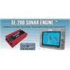
SE200C Sonar engine with 2 Thru Hull Transducers U1-200C-00E 1200c00e
-
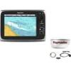
Package(c95 with USA Coastal Chart, 4KW 24 Inch Digital Radome & Radar Cable)
-
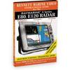
DVD Raymarine E Series E80 E120 Radar N7802DVD
-
E52081E - 4KW Super HD Digital Pedestal w/ VCM100
-
Fish-N-Map 8263; Map-Lake Shasta
-
SP110VF-2 Autopilot with Virtual Feedback and 18CI Reversing PU
-
Marine Instruments 33832 0-6000 rpm Tachometer with Hourmeter
-
0526003PLB 3" Bronze Deck Plate
-
SP-80MS Mechanical Dash Drive w/ Built in Feedback
-
Inc ETS046717 Computer Hardware
-
500 Series 535 Portable - Fishfinder - portable - included transducer - single-beam
-
GPSMAP 4012 - Marine GPS receiver - 10.4" color - 800 x 600