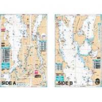
Lake Champlain Fishing South - Waterproof Charts
Designed for recreational boaters, fishermen and divers. Waterproof Charts are beautifully printed on synthetic paper. For use on deck in any weather rain or spray! Accurate, used by Coast Guard and Navy, simple to use with GPS. Foldable and easy to hold and store Waterproof Charts are so tear resistant you can't ruin them. Printed on both sides so they save you money! All Charts are 25"x38" This LARGE PRINT Lake Chart details all of the Major Fishing Areas and pinpoints dozens of specific areas for the major species caught in the area. (Large and Smallmouth Bass, Yellow Perch, Walleye, Muskie, Northern Pike, Salmon & Trout). Many areas have GPS positions. Grass and Marsh areas are also identified. Marinas are listed as well as popular Boat Ramps. From the south, side "A" starts at Whitehall N.Y. and continues north to Burlington Vt. The reverse side continues north from Willsboro Point and Shelburne Bay to Cumberland Head and Savage Island. Information from 3 NOAA Charts; 14782, 14783, 14784. Chart is 25" X 38" and is folded to 7" X 14" « less
Product Specification
-
Universal Product Identifiers
Part Number: 11F
Related Products
-
T70023 C97 Multifunction Display w/Sonar - European Charts
-
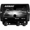
JMA-3340HS Radar 10KW 72 nm, 4 ft Open Array with 27-48 rpm Radar Antenna
-
Max Lakes South NA-M019 c30549
-
010-C0795-10 Bluechart G2 HEU451SLigurian Sea Corsica
-
PFD 33 Gram Manual Inflatable Chest Pak in Navy Size: Small / Medium
-
Bulk cable - CAT 6 - Unshielded twisted pair (UTP) 1000 ft - White
-
WS-CC30 NMEA Combination Cable 30m
-
/ Quicksilver 84-79147A 3 P/T Pump Connector & Harness
-
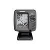
300 Series 365i Combo - Marine Chartplotter - 4" monochrome - 240 x 320
-
3ft 24AWG Cat6 550mhz UTP Ethernet Bare Copper Network Cable - Green
-
Submersible / Floating Handheld 6/5/2.5/1 W VHF Radio
-
GPS 95CP Color LCD GPS/WAAS Chartplotter C30841