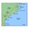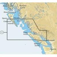
NA-C704 Furuno FP Format Texada Is - Caamano Snd
Model: NA-C704 Brand: C-Map
With are Electronic Sharts C-Maps we have: Olympia, Washington to Port Mcneill, British Columbia. Nannose to Victoria to Cape Scott Texada Island to Caamano Sound Cape Caution to Portland Canal Banks Island, British Columbia to Sumner Strait, Alaska Dixon Entrance to Icy Bay Gulf of Alaska Western Alaska NA-C704 Texada Island To Caamano Sound NT+ Cartography NT+ electronic charts feature much wider coverage areas at substantially lower prices. « less
Product Specification
-
Universal Product Identifiers
Part Numbers: 20182, NA-C704FURUNOFP
Related Products
-
MapSource BlueChart - Carolinas - Maps
-
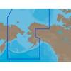
NA-C804 Furuno FP Format Northern Alaska
-
701S-00616 ARH100 Automatic Hydostatic Release Housing
-
Hook & Loop Fastening Cable Ties 13inch, 100pcs/Pack - Black
-
OK105 18inch SATA Data and Power Combo Cable - UV Blue
-
SCSI internal cable - 68 pin HD D-Sub (HD-68) - M - 4.6 ft - PC
-
25ft 24AWG Cat5e 350MHz UTP Bare Copper Ethernet Network Cable - Gray
-
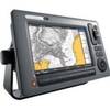
E62111-US - C90Wide 9 MFD, US Charts, Int GPS
-
ZDIGUSBNMEA NMEA Adapter
-
2206 Terminal Feed Thru 3/8 L Red
-
1- Light Bar for 24" SatDomes - Requires Ltb Top, LTB-S24
-
Waterproof VHF DSC w/Hailer White