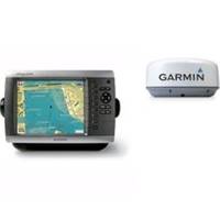
Radar 4008 Package with GMR18 4KW Radome
Model: GMR18 Brand: Garmin
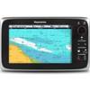
The package includes Garmin GPS Chartplotter Garmin GPS Antenna Garmin Radome Garmin Power, GPS, and Radar cables Manuals The power of networking meets the brilliance of great design in this chartplotter, which serves as your all-in-one nerve center? for the Garmin Marine Network. The GPSMAP 4008 has video-quality resolution on an 8.4? VGA display as well as a worldwide, satellite-enhanced basemap. By connecting to the Garmin Marine Network, you can add sonar, radar and weather. For even more enhanced features, you can add the optional BlueChart g2 Vision card. View Detailed Graphics and Video The 4008 features a worldwide basemap with high-quality satellite images in place of more traditional maps. And for more detail, you can add maps easily with the SD card slot without having to connect to a computer. The 4008? s high-speed processor draws maps quickly, and its simple intuitive interface makes navigating easy. To keep tabs on your engine room or other area of your boat, you can also connect a live video feed with the 4008? s video input and output options. Add Extras with BlueChart g2 Vision With the optional BlueChart g2 Vision SD card, you can add a whole new dimension of exceptional features to your chartplotter. 3D mariners eye view or fish eye view provides you with a 3-dimensional perspective of map information, both above the waterline and below it. High-resolution satellite images and aerial photographs help you orient yourself in unfamiliar areas. Auto Guidance technology searches through all relevant charts to create a route you can actually follow one that avoids obstacles, shallow water, buoys and other obstructions. Connect to the Garmin Marine Network The 4008 connects easily to the high-speed Garmin Marine Network, so you can interface with additional MFDs and add remote sensors. Once connected, you can share information between the 4008 and other chartplotters on your boat. You can also add high-powered radar, sonar and XM satellite weather and radio to your system. A, Mar, 2007 | Download GPSMAP 4000 Quick Reference Guide, Rev. A, Apr, 2007 | Download GPSMAP 4000/5000 Installation Instructions, Rev. B, May, 2007 | Download GPSMAP 4000/5000 Owner's Manual, Rev. B, Aug, 2007 | Download Important Safety and Product Infomation Marine, Rev. A, May, 2007 | Download EL Owner's Manual, Rev. A, Jun, 2007 | Download EL Quick Reference Guide, Rev. A, May, 2007 | Download FR Manuel d utilisation, Rev. A, May, 2007 | Download IT Instrucciones de installacion, Rev. A, May, 2007 | Download NO brukermanual, Rev. A, May, 2007 | Download PT manual do proprietario, Rev. A, Jun, 2007 | Download PT Quick Reference Guide, Rev. A, May, 2007 | Download RU Owner's Manual, Rev. A, Jun, 2004 | Download RU Quick Reference Guide, Rev. A, May, 2007 | Download « less
Product Specification
-
Universal Product Identifiers
Part Number: gmrpack39
Related Products
-
M81136 T2 Rotary Drive 12V
-
T70025 C97 Multifunction Display w/Sonar - Row Charts
-
BlueChart g2 Vision - North Slope Alaska - Maps
-
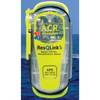
2881 ResQLink Plus PLB375
-
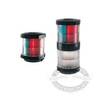
Marine 2984601 Series 2984 Navigation Lamp Tri Color, All Round Light
-
332037 LED Starboard Side Mount White
-
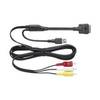
CCA750 - iPhone / iPod audio / video / data cable - Male Apple Dock connector to M 4 pin USB Type A, RCA
-
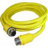
50 Amp 25' Cord Set - Yellow - 125/250V
-
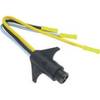
Trolling Motor CONNECTOR, Male, Motor Side #7647-7
-
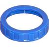
30RB 30 Amp - Ring (Blue)
-
HX471 VHF Radio, 5W Submersible Tri Band HH Silver
-
GPSMAP 525 - Marine GPS receiver - 5" color - 640 x 480