Radar 5208 Package with GMR24HD 4KW Radome & GSD22 Sounder
Model: GMR24HD Brand: Garmin
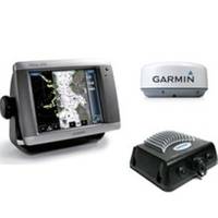
The package includes Garmin GPS Chartplotter Garmin GPS Antenna Garmin Radome Garmin Sounder GSD22 Garmin Power, GPS, and Radar cables Manuals This flagship marine navigator is missing just one thing buttons. The GPSMAP 5208 features an unprecedented touchscreen interface, along with preloaded BlueChart g2 maps of the U.S. coast and an 8.4" screen that makes navigation as easy as pointing your finger. By connecting to the Garmin Marine Network, you can add sonar, radar and weather. For even more advanced features, you can add the optional BlueChart g2 Vision card. View Detailed Graphics and Video The GPSMAP 5208 features highly-detailed BlueChart g2 marine cartography of the costal United States, including Alaska, Hawaii and the Bahamas. For other areas, the 5208 has a worldwide basemap with high-quality satellite images in place of more traditional maps. With the SD card slot, you can add additional maps without having to connect to a computer. The 5208? s large screen displays crisp, high-resolution graphics so you can easily see where youre going. To keep tabs on your engine room or other area of your boat, you can also connect a live video feed with the 5208's video input/output options. Add Extras with BlueChart g2 Vision With the optional BlueChart g2 Vision SD card, you can add a whole new dimension of exceptional features to your chartplotter. 3D mariner's eye view or fish eye view provides you with a 3-dimensionsl perspective of map information, both above the waterline and below it. High-resolution satellite images and aerial photographs help you orient yourself in unfamiliar areas. Auto Guidance technology searches through all relevant charts to create a route you can actually follow one that avoids obstacles, shallow water, buoys and other obstructions. Connect to the Garmin Marine Network The 5208 connects easily to the high-speed Garmin Marine Network, so you can interface with additional MFDs and add remote sensors. Once connected, you can share information between the 5208 and other chartplotters on your boat. You can also add high-powered radar, sonar, and XM satellite weather and radio to your system. D, Jan, 2008 | Download NMEA 2000 Network Fundamentals, Rev. A, Jan, 2008 | Download Owner's Manual, Rev. B, Jul, 2007 | Download Quick Reference Guide, Rev. B, Jan, 2008 | Download EL Quick Reference Guide (Greek), Rev. B, Jan, 2008 | Download RU Quick Reference Guide (Russian), Rev. B, Jan, 2008 | Download Some downloads may require Adobe Acrobat Reader. Download a free copy here . « less
Product Specification
-
Universal Product Identifiers
Part Number: gmrpack18
Related Products
-
MT-403FG AccuSat 406 Cat 1 EPIRB Intern GPS Non-Hazmat Withbracket
-
Video Sboatsmdvd DVD Boaters Guide to Twin
-
ME-C005 Furuno FP Format - Caspian Sea
-
Nauticomp Signature 12 Inch Sunlight Marine Display, Flush Mount
-
010-C0759-10 Bluechart G2 HAW451SRed Sea Data Card
-
Hydrographical Surveying: A Description of the Means and Methods Employed in Construcing Marine Charts [Book]
-
Cal June 722 Safety Harness Child
-
SP-70R Autopilot w/Pump w/Rotary Feedback
-
Lopo Light Single Stb Vessel Size 40
-
35ft Super VGA M/F CL2 Rated (for In-Wall Installation) Cable w/ Ferrites (Gold Plated)
-
Cat6a Ethernet Cable | 2ft | Blue | Network | 10 Gigabit
-
Tram 1655 8-ft Marine GPS Antenna