SD651P Cent Gulf of MX Plat+On M155Sd
Model: SD651P Brand: Navionics
Navionics 651P+ Central Gulf of Mexico Platinum+ Multi-Dimensional Charts, with the most advanced technology and best imaging available, provide high-resolution photo/chart overlay, full-view XGA panoramic pictures, improved 3D view, complete geo-referenced coast pilots. Compatibility Guide « less
Product Specification
-
Universal Product Identifiers
Part Numbers: 11093986, 37666, 651P+, DEF-257882MSD651, MSD, MSD-651P-, MSD651P+, NVNMSD651PP, SD651PGTIN: '82124565159, 00821245651594
Related Products
-
CH250BB/150/240 150 kHz Black Box Searchlight Sonar System. Includes 400mm Travel Hoist and Operates at 12VDC
-
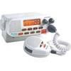
Mr F55 Marine Fixed Mount VHF 25 watt, White
-
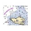
NOAA 17403 Davidson Inlet & Sea Otter Sound, Edna Bay Chart
-
NA-C703 Furuno FP Format Cape CAUTION - Portland Canal
-
MSD/673P+ Platinum Plus Maine on SD/Micro SD
-
GA-0100070520 - GHP 10V Autopilot Corepack (Volvo Ips)
-
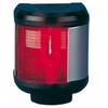
40300-7 S40 Port Navigation Light 12v/25w
-
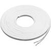
Marine Speaker Cable - XM-WHTSC16-25
-
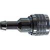
PHF1 Female Phone Connector
-
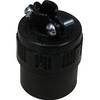
18-8062 Fuel Line Connector 5/16"
-
Marine EC7E GPS-Chartplotter/Fish Finder with External Antenna, C-Map Max Card & 7" Color Display; NMEA Network Compatible - SI-TEX
-
HDS-8 - Marine Chartplotter - 8" color - 800 x 600