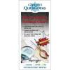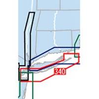
Waterproof Chart Kit - South Shore Long Island #WPB0340-02
Model: WPB0340-02 Brand: Maptech
Waterproof Charts w/ Companion CD WPB0340 340: South Shore Long Island NY Harbor's Lower Bay to Montauk and Block Island. 25 chart pages, GPS waypoints, Lat. /Long. grids, pre-plotted courses, ramps, and 340 marine facilities. 12 x 17, scales 1:1,263,000 to 1:26,000. Product Overview These easy-to-use, compact chart books are ideal for Day-Sailors, Fishing Boats, and Trailer Boats. They measure 12 x 17 (24 x 17 when open) and are made of waterproof, tear-resistant synthetic paper that will withstand the elements. GPS Ready New features make Waterproof Chartbooks easy to use with your GPS. Most charts include one-minute lat./long. grids to make vessel positioning a breeze, and major navigation aids are identified with named GPS waypoints. Small and Large-Scale Charts Waterproof Chartbooks include small-scale, wide area charts as well as large-scale, detailed charts of harbors and approaches. « less
Product Specification
-
Universal Product Identifiers
Part Number: WPB0340-02
Related Products
-
eTrex H - iking GPS receiver - Monochrome - 64 x 128
-
X515c DF 5" Dual Frequency Sonar 123-34
-
FR8122 12.1 Color LCD 12KW 15 Mtr Cbl No Antenna
-
3G Broadband Radar Dome with 10 Meter Cable for HDS models 000-10418-001 c41760
-
010-C1020-10 Bluechart G2 HPC024RAustralia & New Zealand Data
-
How to Read A Nautical Chart: A Complete Guide to the Symbols, Abbrevi
-
290 Marine Navigation ROADrule Marine Navigation Aids
-
E120W Chartplotter U.S. Coastal Charts E62223-US
-
Cat6a Ethernet Cable | 5ft | Blue | Network | 10 Gigabit
-
250ft 14AWG CL2 Rated 4-Conductor Loud Speaker Cable (for
-
Pandora Featured Network audio player
-
SmartPlug BF50 50 Amp Boatside Connector