5209; Map-Roosevelt Lake
Model: 5209 Brand: Fish-n-Map
FISH-N-MAP UNDERWATER TOPOGRAPHY MAPSMade of waterproof, tear resistant plastic. Features include: underwater depth contours, fish locations, latitude and longitude for GPS, multiple freshwater lakes on one map, boat ramps, recreational facilities and much more.
Product Specification
-
Universal Product Identifiers
Part Numbers: 250137, 5209GTIN: 00761428052094
Related Products
-
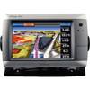
GPSMAP 740 GPS Chartplotter with Internal GPS Antenna 010-00835-02
-
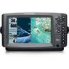
958c HD Di Down Imaging GPS Fishfinder 408710-1 c46192
-
E70022 E97 Multifunction Display w/Sonar - No Charts
-
XN12A/4 4' Open Array Antenna
-
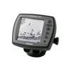
Fishfinder 140 - Fishfinder - included transducer - dual-beam
-
E92143 - 4KW 24 HD Digital Radome w/o Cable
-
1964CBB Radar Chartplotter, Black Box, 6' Antenna & C-Map
-
500 Series 596c - Fishfinder - included transducer : XNT-9-20-T - dual-beam
-
E120W Chartplotter U.S. Coastal Charts E62223-US
-
10ft 24AWG Cat5e 350MHz UTP Bare Copper Ethernet Network Cable - Pink
-
/ Quicksilver 862994T Connector
-
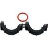
010-11170-02 - Split Collar w/ 14.5mm Connector