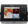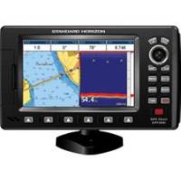
7" GPS CHARTPLOTTER/FF W/MAPS
Model: Brand: Standard Horizon
Standard Horizon CPF390i CPF390i 7 Internal GPS Chart Plotter Fish Finder Combo with built-in C-Map Cartography The CPF390i comes preloaded with detailed maps for coastal navigation of the USA, Great Lakes, Canada, Hawaii, Mexico and the Bahamas. The CPF390i boasts a 7-inch crisp high-resolution 800x480 sunlight viewable 16 9 aspect ratio Wide Screen display. 10 accuracy is obtained with the integrated 50 channel WAAS GPS receiver or optional GPS Smart antenna. The built-in 600W dual frequency fish finder allows you to easily find wrecks, record water temperature and target fish, simply by connecting an optional transducer. NMEA connections are available to compatible VHF s for DSC distress and position polling functions. Connect your CPF390i to a video source and watch your favorite DVD, play your favorite video game, or monitor your engine room in full screen or Picture in Picture. Dedicated MARK, ROUTE and INFO keys allow for fumble free operation. 5 user programmable hot keys a « less
Product Specification
-
Universal Product Identifiers
Part Numbers: 12008322, 40652, CPF390I, DEF-258481, Standard Horizon CPF390i, STDCPF390IGTIN: 00788026124114
Related Products
-
Mastering Marine Radar [DVD]
-
Sd/630P+ E Gulf of MX Plat+On M155Sd
-
SmartCast RF35 - Fishfinder - portable - included transducer : RF45 - single-beam
-
EPIRB with GPS Manual Release Cat II EG50 Manual c30588
-
POD-4S 4 Person Life RAFT- Soft Valise
-
0835006PLB Seacock w/Straight TP 1in
-
000-10196-001 - NSS8 US 8 Touchscreen MFD/Sounder
-
320-00246-10 15m Marine Radar Power Cable
-
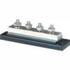
2104 PowerBar 600 Ampere Cable Connector 4 x 3 8 16 Stud ter
-
SeatalkHS Network Cable
-
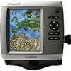
GPSMAP 521 - Marine Chartplotter - 5" color - 234 x 320
-
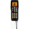
VH-310 Second Station Remote Telephone Handset