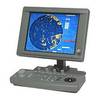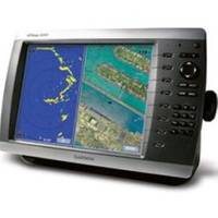
GPSMAP 4010 Plotter with GPS Antenna 010-00690-00
Model: 010-00690-00 Brand: Garmin
This mid-sized 4000 series chartplotter fills the gap between the smaller GPSMAP 4008 and the wider GPSMAP 4012. Like its counterparts, the 4010 serves as your all-in-one "nerve center" for the Garmin Marine Network. This chartplotter has crisp, video-quality resolution on a 10.4" diagonal SVGA display as well as a worldwide, satellite-enhanced basemap. By connecting to the Garmin Marine Network, you can add sonar, radar and weather. For even more enhanced features, you can add the optional BlueChart g2 Vision card. View Detailed Graphics and Video The 4010 features a worldwide basemap with high-quality satellite images in place of more traditional maps. And for more detail, you can add maps easily with the SD card slot without having to connect to a computer. The 4010's high-speed processor draws maps quickly, and its simple, intuitive interface makes navigating easy. To keep tabs on your engine room or other areas of your boat, you can also connect a live video feed with the 4010's video input option. Add Extras with BlueChart g2 Vision With optional BlueChart g2 Vision SD cards, you can add a whole new dimension of exceptional features to your chartplotter. Choose to view 3D map information at "mariner's eye view" above the waterline or "fish-eye view" below the water. High-resolution satellite images and aerial photographs help you orient yourself in unfamiliar areas. Auto Guidance technology searches through all relevant charts to create a route you can actually follow - one that avoids obstacles, shallow water, buoys and other obstructions. Connect to the Garmin Marine Network The 4010 connects easily to the high-speed Garmin Marine Network, so you can interface with additional MFDs and add remote sensors. Once connected, you can share information between the 4010 and other chartplotters on your boat. You can also add high-powered radar, sonar and XM satellite weather and radio to your system. « less
Product Specification
-
Universal Product Identifiers
Part Number: GAR0100069000
Related Products
-
408470-1 581i Di Combo Fishfinder
-
LX - I Compact Hand - Held Digital Sonar
-
JMA-5104 Black Box Radar 48 NM with 4KW 24 Inch Dome without Display
-
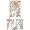
Canadian Charts 3312 Jervis Inlet and / et Desolation Sound Chart
-
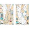
Rockport to Bangor, Maine Nautical Marine Charts - Waterproof Charts
-
Lake Champlain Fishing South - Waterproof Charts
-
010-C0772-20 Bluechart G2 HXEU014RItaly Adriatic Sea Microsd/sd
-
Practical Marine Navigation [Book]
-
25ft 24AWG CL2 Standard HDMI Cable - Black
-
252130 Butt Connector #8 HD 2/pk
-
NAC-MRD2MBL Adapter Cable - 127-04
-
GPSMAP 76S - Marine, hiking GPS receiver - Monochrome - 240 x 180