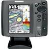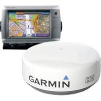
GPSMAP 740S Radar Pack with GMR 24HD Radome c44403
Model: 740S Brand: Garmin
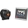
GPSMAP 740 is a stand-alone touchscreen chartplotter that brings a new level of functionality to your vessel. Featuring a brilliant 7-inch display, GPSMAP 740 puts all the information you need right at your fingertips. GPSMAP 740 is preloaded with U.S. coastal maps. In addition, GPSMAP 740 accepts radar input and offers full NMEA 2000 connectivity for greater convenience when adding extra sensors. Explore the Seas GPSMAP 740 contains preloaded map data for all U.S. coastal areas, including Alaska and Hawaii, plus Explorer Charts for the Bahamas. GPSMAP 740 also features an internal, high-sensitivity GPS receiver for superior satellite tracking and quicker acquisition times. And as an added benefit, GPSMAP 740 can receive graphical weather data for North America through the optional GXM 51 satellite receiver/antenna. Take Control by Touch Input is easy with GPSMAP 740. Whether youre changing course or simply reviewing information in front of you, the intuitive touchscreen interface makes for simple operation. The device also offers flexible brightness levels for daytime readability along with low-light dimming during night use. And with a widescreen display thats rugged and waterproof, its made to perform in any situation. Expand with Radar Featuring a built-in radar port, GPSMAP 740 can be interfaced with Garmins line of affordable GMR marine radar systems . Whether youre adding radar now or in the future, youll enjoy the convenience of plug-and-play installation? as well as the power, range and high-definition targeting of our proven radar offerings. Add Sonar with GPSMAP 740s GPSMAP 740s comes standard with a 1k - W-capable sonar transceiver. This powerful sonar can help you define fish targets and underwater structures as far down as 2,000 feet when used with a 1k - W transducer. Add Extras with Blue - Chart g2 Vision With the optional Blue - Chart g2 Vision SD card, you can add a whole new dimension of exceptional features to your chartplotter. - Eye view and Fish - Eye view provide you a 3-dimensional perspective of map information, both above and below the waterline. High-resolution satellite images and aerial photographs help you orient yourself in unfamiliar areas. Auto Guidance technology searches through all relevant charts to create a route you can actually follow one that avoids obstacles, shallow water, buoys and other obstructions. Garmin Marine Network not supported. Depth capacity is dependent on water salinity, bottom type and other water conditions (with 1 k - W transducer). Physical & Performance: Unit dimensions, WxHxD: 8.8" x 5.6" x 3.1" (22.4 x 14.2 x 7.9 cm) Display size, Wx - H: 6.0" x 3.6", 7.0" diagonal (15.2 x 9.1 cm, 17.8 cm diagonal) Display resolution, Wx - Chart g2 Vision card) Auto Guidance: yes (with optional Blue - Chart g2 Vision card) XM WX Weather & Radio for U.S. & Canada compatible: yes Automatic routing (turn by turn routing on roads): no Voice prompts (e.g. "Turn right in 500 ft."): no Speaks street names (e.g. B May 2010 190-01155-01 Download Technical Reference for Garmin NMEA 2000 Products Rev. C Jul 2010 190-00891-00 Download Garmin GMR24 HD Radar 24 inch 4Kw 48Nm Range High Definition Dome Sharpen your radar picture with high definition. The GMR 24 HD radar scanner offers a whole new level of radar performance, safety and situational awareness. Get Powerful Performance GMR 24 HD features high-powered Digital Signal Processing, providing sharper radar imagery and improved target separation to recreational boaters, professional mariners and yachtsmen. This 24-inch, 4-kilowatt high definition radar has a 3.6 degree beamwidth and a 48 nm range. With automatic pulse optimization technology, the radar matches pulse widths and repetition rates with the nautical mile range that is selected. This gives you powerful 4-kilowatt radar penetration and unbelievably clear echo definition at all ranges up to 48 nm. To help you avoid traffic on the water, the GMR 24 HD provides the option of MARPA target tracking when combined with a multi-function display and an optional heading sensor. MARPA tracking allows you to track the bearing, course, speed and predicted closest approach of up to 10 targets. In addition, like all Garmin radars, the GMR 24 HD has self-contained signal processing, which provides you with a more precise, easy to read signature. Connect to the Garmin Marine Network The GMR 24 HD transmits data over the Garmin Marine Network, a 100-megabit plug-and-play proprietary network that gives you the ability to expand your boats system as needed. Once connected to the network, you can use any network-compatible Garmin chartplotter as your radar screen. And as an aid to locational awareness, you can overlay the GMR 24 HD radar image on the chartplotter's map page. You can also split the on-screen display so that you can view the map and the standard radar page simultaneously. « less
Product Specification
-
Universal Product Identifiers
Part Number: c44403
Related Products
-
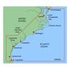
MapSource BlueChart - Carolinas - Maps
-
MapSource BlueChart - Chesapeake - Maps
-
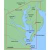
8265; Map-Lake Camanche/Folsom Lake
-
EFLH2009R MD520N LED Navigation Light Set
-
GHP20 Marine Autopilot System for Steer-by-Wire 010-00705-55
-
700 Series 787c2i Combo - Marine Chartplotter - 5" color - 640 x 480
-
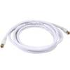
12ft RG6 (18AWG) 75OHM, Quad Shield, CL2 Coaxial Cable with F Type Connector - White
-
55-0023 Transom Adaptor - 550012/21/22
-
SM 01-1050000 Manifold Adapter Plate (Pair)
-
Marine Products Plug, Lower Unit Drain 9-72655
-
Marine Products Plug Wire Set 9-28034
-
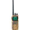
VHF55sc VHF Two-way radio